


Minneapolis and Seattle bucked national trends by increasing active transportation and use of public transit in recent years.
As cities across the U.S. struggle to sustain transit ridership, Minneapolis and Seattle have distinguished themselves with high rates of non-car commuting, according to a recent report from the Institute for Transportation and Development Policy.
Streetsblog's Angie Schmitt reports that despite gaining 30,000 residents between 2007 and 2016, Minneapolis reduced vehicle miles traveled by 2 percent over that time. In Seattle, average daily traffic fell 5 percent between 2006 and 2017.
"Believe it or not, this is a rare feat," Schmitt writes, noting that low gas prices, population growth, and the rise of ride-hailing services have made reducing driving "one of the hardest codes [to crack] in city planning."
The strategies that led to these results won't be surprising to many transportation planners. They fell along three major lines:
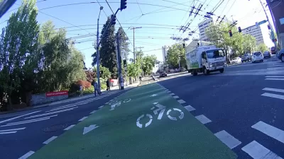
- Investment in public transit, both bus and rail. Both Seattle and Minneapolis are in the midst of building or expanding their BRT networks, and both have opened new rail lines in recent years. Seattle voters in particular have shown willingness to fund transportation.
- Investment in bike infrastructure. Both cities are "famously bike friendly," with Seattle being named Bicycling Magazine's Top Biking City in America in 2018.
- Urban infill and dense, walkable development. Seattle recently launched a program to build affordable apartments on public land adjacent to light rail, while Minneapolis saw nearly $1 billion in downtown development in 2017 and eliminated parking requirements in 2018.
FULL STORY: How Two Cities Actually Reduced Driving

Seattle Mayor Raises Transportation Levy by $100 Million
The proposal sent to City Council includes more funding for multimodal transportation and road safety.
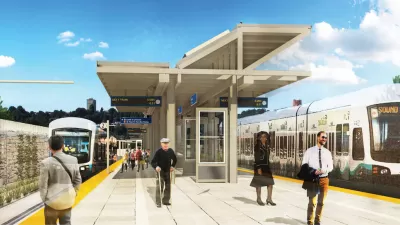
Seattle Area Developers Target Areas Around Light Rail Extension
The East Link line, which will connect Redmond and Bellevue to Seattle in 2025, is spurring transit-oriented development near future stations.

Seattle Mobility Advocates Say City Should Triple Transportation Levy
A measure set to go before voters in November will fund road safety and mobility projects, but advocates say a much bigger investment is required to meet the city’s needs.

Maui's Vacation Rental Debate Turns Ugly
Verbal attacks, misinformation campaigns and fistfights plague a high-stakes debate to convert thousands of vacation rentals into long-term housing.

Planetizen Federal Action Tracker
A weekly monitor of how Trump’s orders and actions are impacting planners and planning in America.

In Urban Planning, AI Prompting Could be the New Design Thinking
Creativity has long been key to great urban design. What if we see AI as our new creative partner?

King County Supportive Housing Program Offers Hope for Unhoused Residents
The county is taking a ‘Housing First’ approach that prioritizes getting people into housing, then offering wraparound supportive services.

Researchers Use AI to Get Clearer Picture of US Housing
Analysts are using artificial intelligence to supercharge their research by allowing them to comb through data faster. Though these AI tools can be error prone, they save time and housing researchers are optimistic about the future.

Making Shared Micromobility More Inclusive
Cities and shared mobility system operators can do more to include people with disabilities in planning and operations, per a new report.
Urban Design for Planners 1: Software Tools
This six-course series explores essential urban design concepts using open source software and equips planners with the tools they need to participate fully in the urban design process.
Planning for Universal Design
Learn the tools for implementing Universal Design in planning regulations.
Appalachian Highlands Housing Partners
Gallatin County Department of Planning & Community Development
Heyer Gruel & Associates PA
Mpact (founded as Rail~Volution)
City of Camden Redevelopment Agency
City of Astoria
City of Portland
City of Laramie