


Anticipating the opening of two new stations in 2024, the Seattle Department of Transportation released a study prioritizing bike infrastructure in the surrounding areas.
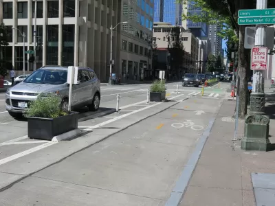
A new study from the Seattle Department of Transportation (SDOT) recommends bike and pedestrian improvements for two new light rail stations being built on the city's north side, which currently have few connections to the existing bike network. A map showing "level of traffic stress" for people on bikes indicates mostly high-stress routes in the area surrounding the two stations. "Pretty much every east-west route someone would use to access either station" is a high-stress corridor, writes Ryan Packer, which makes it difficult for bike commuters to access the train.
The projects proposed in the study build on top of improvements that SDOT already plans to implement at the new stations and would improve safety and connectivity between the train stations and other parts of town. The highest-ranked priority projects—which include improving the I-5 crossing at 130th Street, adding a shared-use path to 145th Street, widening and improving the Jackson Park trail, and extending bike lanes on Roosevelt Way—involve improvements that provide direct access to the future stations. "The rest of the network builds on these projects," making them part of a crucial foundation for improving Seattle's bike and pedestrian infrastructure.
The study lays out proposed improvements, but funding for the projects remains an open question. "Identifying funding sources is pretty important to getting these actually built, but it’s likely there will be a lot of competition for those pots of money when they become available," writes Packer.
FULL STORY: New study recommends slew of biking improvements around coming north Seattle light rail stations

Seattle Mayor Raises Transportation Levy by $100 Million
The proposal sent to City Council includes more funding for multimodal transportation and road safety.

Seattle Mobility Advocates Say City Should Triple Transportation Levy
A measure set to go before voters in November will fund road safety and mobility projects, but advocates say a much bigger investment is required to meet the city’s needs.
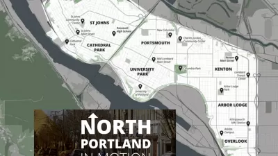
North Portland in Motion Launches with Goals to Improve Walking, Biking, and Transit
The Portland Bureau of Transportation continues its work of drafting transportation plans targeted to specific geographic corners of the city,

Planetizen Federal Action Tracker
A weekly monitor of how Trump’s orders and actions are impacting planners and planning in America.

Map: Where Senate Republicans Want to Sell Your Public Lands
For public land advocates, the Senate Republicans’ proposal to sell millions of acres of public land in the West is “the biggest fight of their careers.”

Restaurant Patios Were a Pandemic Win — Why Were They so Hard to Keep?
Social distancing requirements and changes in travel patterns prompted cities to pilot new uses for street and sidewalk space. Then it got complicated.

Platform Pilsner: Vancouver Transit Agency Releases... a Beer?
TransLink will receive a portion of every sale of the four-pack.

Toronto Weighs Cheaper Transit, Parking Hikes for Major Events
Special event rates would take effect during large festivals, sports games and concerts to ‘discourage driving, manage congestion and free up space for transit.”

Berlin to Consider Car-Free Zone Larger Than Manhattan
The area bound by the 22-mile Ringbahn would still allow 12 uses of a private automobile per year per person, and several other exemptions.
Urban Design for Planners 1: Software Tools
This six-course series explores essential urban design concepts using open source software and equips planners with the tools they need to participate fully in the urban design process.
Planning for Universal Design
Learn the tools for implementing Universal Design in planning regulations.
Heyer Gruel & Associates PA
JM Goldson LLC
Custer County Colorado
City of Camden Redevelopment Agency
City of Astoria
Transportation Research & Education Center (TREC) at Portland State University
Camden Redevelopment Agency
City of Claremont
Municipality of Princeton (NJ)