


The San Francisco Chronicle offers a round-up of 11 big transit projects, by Caltrans, BART, SFMTA, and others, making progress around the bay.
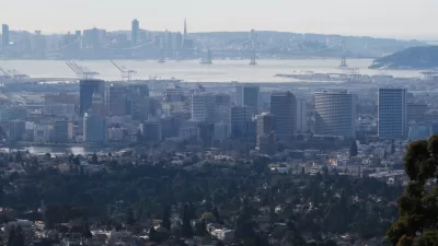
From the Central Subway to the Geary Boulevard Bus Rapid Transit Line to the Caltrain electrification, there’s plenty going on in Bay Area public transit. An article by Michael Cabanatuan maps and outlines the region's 11 biggest transportation projects, starting with the Central Subway. "Muni’s Central Subway will carry passengers from the Caltrain terminal down the middle of Fourth Street, descend into a tunnel between Bryant and Harrison streets and make a subterranean journey beneath the busiest parts of the city — passing under the BART tracks and heading below Stockton Street — to arrive in Chinatown’s Washington Street Station," Cabanatuan writes.
While most of these projects are public transit related, the San Rafael Bridge bike path is also scheduled to open in a few months, as well as new carpool lanes set to reach San Jose, San Francisco, Oakland, and beyond.
FULL STORY: The Bay Area's 11 biggest transportation projects

Op-Ed: To Survive, Bay Area Transit Needs Integration
Advocates for ‘seamless’ transit are calling on California state leaders to tie a consolidation study to a one-time injection of funding into the Bay Area’s transit systems.
Bay Area Planners Acknowledge the Need for Regional Housing Solutions
While most Bay Area communities are pursuing housing solutions "individually," local planners acknowledge the need for strategies that address the regional as a unified whole.
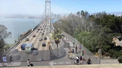
Planning Underway for New Bay Bridge Bike Path, and a Second Transbay BART Tube
In a distant and expensive future, there are two new ways to get across the San Francisco Bay without a car. One will have a much better view.

Planetizen Federal Action Tracker
A weekly monitor of how Trump’s orders and actions are impacting planners and planning in America.

Map: Where Senate Republicans Want to Sell Your Public Lands
For public land advocates, the Senate Republicans’ proposal to sell millions of acres of public land in the West is “the biggest fight of their careers.”

Restaurant Patios Were a Pandemic Win — Why Were They so Hard to Keep?
Social distancing requirements and changes in travel patterns prompted cities to pilot new uses for street and sidewalk space. Then it got complicated.

Platform Pilsner: Vancouver Transit Agency Releases... a Beer?
TransLink will receive a portion of every sale of the four-pack.

Toronto Weighs Cheaper Transit, Parking Hikes for Major Events
Special event rates would take effect during large festivals, sports games and concerts to ‘discourage driving, manage congestion and free up space for transit.”

Berlin to Consider Car-Free Zone Larger Than Manhattan
The area bound by the 22-mile Ringbahn would still allow 12 uses of a private automobile per year per person, and several other exemptions.
Urban Design for Planners 1: Software Tools
This six-course series explores essential urban design concepts using open source software and equips planners with the tools they need to participate fully in the urban design process.
Planning for Universal Design
Learn the tools for implementing Universal Design in planning regulations.
Heyer Gruel & Associates PA
JM Goldson LLC
Custer County Colorado
City of Camden Redevelopment Agency
City of Astoria
Transportation Research & Education Center (TREC) at Portland State University
Camden Redevelopment Agency
City of Claremont
Municipality of Princeton (NJ)