


In a distant and expensive future, there are two new ways to get across the San Francisco Bay without a car. One will have a much better view.
"Long the holy grail for cycling advocates in the Bay Area — a bike and pedestrian path spanning the entire length of the Bay Bridge, offering unparalleled views of San Francisco and a carbon-free alternative to soul-sucking traffic — has, for decades, remained tantalizingly out of reach," writes Erin Baldassari.
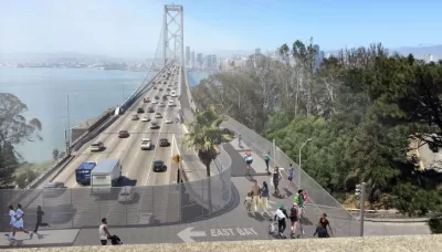
That holy grail is one step closer to becoming a reality, however, after the Metropolitan Transportation Commission, a regional planning agency spanning nine Bay Area counties, revealed a new study of the Bay Bridge West Span Bike Path last week.
The recent report narrows down six design alternatives created and presented to the public in 2016 to a preferred design alternative. According to the Metropolitan Transportation Commission website set up to promote the project, "[the preferred design alternative] features an alignment running along the north side of the West Span with a touchdown in San Francisco at Essex Street (parallel to First and Second streets, between Folsom to the north and Harrison to the south). The recommendation for the Yerba Buena Island connection joins the East Span path via Southgate Road along the east side of Hillcrest Road. The path would share architectural features will the East Span path, providing continuity of experience along the entire crossing."
According to Bladessari, the new report is the closest regional planners have come to "understanding the full magnitude of construction and its associated costs" (which, by the way, are estimated at $341 million to nearly $429 million).
But wait, there's more non-automotive transportation planning news from the Bay Area: BART has also announced a new planning process for a second transbay tube
Adam Bronklow reports: "The possibility of a second tube—BART’s official announcement suggests that 'tube' may not be the correct term for whatever the agency ends up building, instead stressing the term 'second crossing'—has floated around the Bay Area for decades, but this is the first time BART appears to be planning concrete measures for it."
The BART website set up to promote the planning process includes a list of opportunities and objectives for the project. Among the objectives, the ability to double BART bay crossing capacity.
Brinklow's coverage provides context of the growing popular and political support for the crossing.
FULL STORY: Bay Bridge bike path on west span would offer ‘breathtaking views’ — and a huge price tag

Recommendations for Improving the Bay Area's Busiest Commute
One of the nation's busiest commute corridors will get a lot busier in coming decades with no large infrastructure investment in sight. SPUR has some ideas about how the East Bay to San Francisco corridor can be improved right now.

$100 Billion Bay Area Transportation Tax Considered for November 2020 Ballot
Two years after voters in the nine-county Bay Area agreed to hike tolls on the region's seven state-owned bridges, regional business leaders are hoping they will approve a one-cent regional sales tax to fund $100 billion in transportation projects.

The Many Ongoing Public Transportation Projects of the Bay Area
The San Francisco Chronicle offers a round-up of 11 big transit projects, by Caltrans, BART, SFMTA, and others, making progress around the bay.

Planetizen Federal Action Tracker
A weekly monitor of how Trump’s orders and actions are impacting planners and planning in America.

Restaurant Patios Were a Pandemic Win — Why Were They so Hard to Keep?
Social distancing requirements and changes in travel patterns prompted cities to pilot new uses for street and sidewalk space. Then it got complicated.

Map: Where Senate Republicans Want to Sell Your Public Lands
For public land advocates, the Senate Republicans’ proposal to sell millions of acres of public land in the West is “the biggest fight of their careers.”

Maui's Vacation Rental Debate Turns Ugly
Verbal attacks, misinformation campaigns and fistfights plague a high-stakes debate to convert thousands of vacation rentals into long-term housing.

San Francisco Suspends Traffic Calming Amidst Record Deaths
Citing “a challenging fiscal landscape,” the city will cease the program on the heels of 42 traffic deaths, including 24 pedestrians.

California Homeless Arrests, Citations Spike After Ruling
An investigation reveals that anti-homeless actions increased up to 500% after Grants Pass v. Johnson — even in cities claiming no policy change.
Urban Design for Planners 1: Software Tools
This six-course series explores essential urban design concepts using open source software and equips planners with the tools they need to participate fully in the urban design process.
Planning for Universal Design
Learn the tools for implementing Universal Design in planning regulations.
Heyer Gruel & Associates PA
JM Goldson LLC
Custer County Colorado
City of Camden Redevelopment Agency
City of Astoria
Transportation Research & Education Center (TREC) at Portland State University
Camden Redevelopment Agency
City of Claremont
Municipality of Princeton (NJ)