


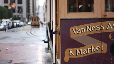
Private automobiles could be prohibited on San Francisco's primary downtown thoroughfare, and already-wide sidewalks could be extended and smoothed over. The Better Market Street project is ready for its close up.
John King reports on proposed changes Market Street in San Francisco, headlined by the complete banning of cars from a particularly busy stretch the street known as Mid-Market.
After several previous efforts to improve the street by preventing cars from turning onto the street, reclaiming public space, and improve access for people with disabilities, King describes the plan expected before the San Francisco Planning Commission this week to give the street what it finally, really needs: a fresh start.
Here are some of details described by King about the project under consideration by the Planning Commission this week:
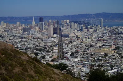
The first phase of the upgrade would extend from Fifth Street to Eighth Street, a $150 million investment in what the city calls Better Market Street. Eventually, the improvements will stretch 2.2 miles between the Embarcadero and Octavia Boulevard, at a current estimated cost of $604 million, some of which will be for sewer and utility updates that were needed anyway.
Market Street will be off-limits to private vehicles east of 10th Street, and commercial loading will only be permitted during specific hours. Ride-hailing companies will only be permitted to drop-off and pick-up in designated zones on side streets.
The already-wide sidewalks would be broadened from 35 to 37 feet, with as much as 12 feet along the curb reserved for bicycle lanes and a curbside buffer zone. The red bricks with their herringbone pattern would be replaced by gray concrete pavers that are easier to clean and repair and more hospitable to wheelchair users.
As noted by King, the process of approving the $604 million project has taken a long time—Planetizen first picked up news of the project in 2017. The final product might just be worth it, however. "Details can be quibbled with, and the process has taken twice as long as it should have, but the results have a disciplined clarity that public initiatives so often lack," writes King.
If planning and construction proceeds from this point as hoped, construction could begin in 2021.
FULL STORY: Market Street makeover — safe bike lanes and no cars — finally at hand


Car-Free Market Street Benefits Micromobility, Transit Without Ruining Car Commutes, Studies Say
Multiple studies have quantified the early results from a project in San Francisco that blocked most private automobile traffic from Market Street in the city's downtown.
Car-Free Market Street Approved in San Francisco
The San Francisco Municipal Transportation Agency Board of Directors approved the Better Market Street plan on October 15, 2019.
Philly Safe Streets Advocates Want What San Francisco and New York Are Having
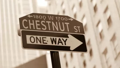
The idea of blocking major streets to private automobiles is making advocates envious in cities that have yet to implement the idea. A petition is circulating to give the car-free treatment to Chestnut Street in Philadelphia.

Planetizen Federal Action Tracker
A weekly monitor of how Trump’s orders and actions are impacting planners and planning in America.

Congressman Proposes Bill to Rename DC Metro “Trump Train”
The Make Autorail Great Again Act would withhold federal funding to the system until the Washington Metropolitan Area Transit Authority (WMATA), rebrands as the Washington Metropolitan Authority for Greater Access (WMAGA).

DARTSpace Platform Streamlines Dallas TOD Application Process
The Dallas transit agency hopes a shorter permitting timeline will boost transit-oriented development around rail stations.

Supreme Court Landlord Appeal Case Could Overturn Tenant Protections
A legal case claiming that COVID-era eviction moratoriums were unconstitutional could spell trouble for tenant protections.

Texas Moves to Curb Orphan Wells, But Critics Say Loopholes Remain
A proposed state law would shift financial responsibility for sealing unused drilling sites from the public to energy operators, though some advocates question its effectiveness due to industry-backed exemptions.

Affordable Housing Finance 101
The financial intricacies involved in building affordable housing can be difficult to understand. This explainer breaks down the foundational concepts.
Urban Design for Planners 1: Software Tools
This six-course series explores essential urban design concepts using open source software and equips planners with the tools they need to participate fully in the urban design process.
Planning for Universal Design
Learn the tools for implementing Universal Design in planning regulations.
Municipality of Princeton
Roanoke Valley-Alleghany Regional Commission
City of Mt Shasta
City of Camden Redevelopment Agency
City of Astoria
Transportation Research & Education Center (TREC) at Portland State University
US High Speed Rail Association
City of Camden Redevelopment Agency
Municipality of Princeton (NJ)