


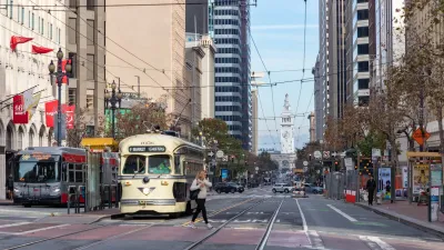
Following precedents from other cities, San Francisco is looking to redesign its famous Market Street by removing automobiles, creating raised bike lanes, implementing faster transit, and making for a more inviting public space.
Turning streets into pedestrian plazas is no novel idea. Implemented in cities worldwide to mixed results, San Francisco now looks to follow the more successful variety, by starting the planning process to change one of its most famous thoroughfares, Market Street, into a more lively public space.
Aaron Bialick, of Streetsblog reports, "[m]any of the concepts...like car-free zones, raised bike lanes, faster transit, and more inviting public spaces...are hallmarks of the world's greatest streets, and planners in the multi-agency effort are aiming to adapt them to Market using a swath of survey data about how the street is used."
Experiments with restricting automobile traffic has proven successful in other cities, like New York City's Broadway and Copenhagen's Nørrebrogade. Like these precedents, Market Street contains a high usage of bicycles and transit, with "85 percent of people on Market Street [getting] there without a car," and "a quarter of transit boardings in SF [taking] place on Market," states Bialick, citing information provided by project staff.
Obstacles remain, such as the estimated $250 million price tag, of which only the funds for re-paving the street are currently available. Still, the project hopes to be completed in 2015.
FULL STORY: Learning From Other Cities, Planners Shop Early Visions for Market Street


Where to Prioritize Buses Next
Advocates in New York City, San Francisco, and Seattle are pushing for more transit and pedestrian priority, and less car-centric streets, as a wave of high-profile projects capture national attention.
Construction Begins Raising San Francisco Bike Lane
A small section of the well-used, protected bike lane on San Francisco's busy Market Street will be raised just a few inches to increase bicycle safety. Construction began Monday and should take a month to complete.
Waymo Gets Permission to Map SF’s Market Street
If allowed to operate on the traffic-restricted street, Waymo’s autonomous taxis would have a leg up over ride-hailing competitors — and counter the city’s efforts to grow bike and pedestrian on the thoroughfare.

Planetizen Federal Action Tracker
A weekly monitor of how Trump’s orders and actions are impacting planners and planning in America.

Map: Where Senate Republicans Want to Sell Your Public Lands
For public land advocates, the Senate Republicans’ proposal to sell millions of acres of public land in the West is “the biggest fight of their careers.”

Restaurant Patios Were a Pandemic Win — Why Were They so Hard to Keep?
Social distancing requirements and changes in travel patterns prompted cities to pilot new uses for street and sidewalk space. Then it got complicated.

Platform Pilsner: Vancouver Transit Agency Releases... a Beer?
TransLink will receive a portion of every sale of the four-pack.

Toronto Weighs Cheaper Transit, Parking Hikes for Major Events
Special event rates would take effect during large festivals, sports games and concerts to ‘discourage driving, manage congestion and free up space for transit.”

Berlin to Consider Car-Free Zone Larger Than Manhattan
The area bound by the 22-mile Ringbahn would still allow 12 uses of a private automobile per year per person, and several other exemptions.
Urban Design for Planners 1: Software Tools
This six-course series explores essential urban design concepts using open source software and equips planners with the tools they need to participate fully in the urban design process.
Planning for Universal Design
Learn the tools for implementing Universal Design in planning regulations.
Heyer Gruel & Associates PA
JM Goldson LLC
Custer County Colorado
City of Camden Redevelopment Agency
City of Astoria
Transportation Research & Education Center (TREC) at Portland State University
Camden Redevelopment Agency
City of Claremont
Municipality of Princeton (NJ)