


If allowed to operate on the traffic-restricted street, Waymo’s autonomous taxis would have a leg up over ride-hailing competitors — and counter the city’s efforts to grow bike and pedestrian on the thoroughfare.
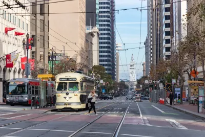
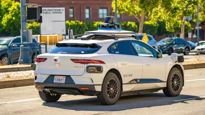
Waymo, the autonomous taxi operator, could soon have access to San Francisco’s Market Street, a major thoroughfare closed to most private vehicles.
As Greg Wong explains in the San Francisco Examiner, the city allowed the company to survey and map the street, paving the way for autonomous taxi service. Currently, Waymo is allowed to operate on most of the city’s streets.
“When asked by The Examiner if there was any other San Francisco street the company does not operate on, Waymo spokesperson Katherine Barna responded that The City ‘has some unique lanes of traffic that are restricted to certain types of vehicles, though none as large or notable as Market Street.’” The company would not elaborate on the exact locations of these streets.
The Better Market Street program only allowed buses, taxis, and commercial vehicles (including Waymo) to operate on the street in an effort to encourage more foot and bike traffic. Now, Mayor Lurie says Waymo will be “another safe and sustainable way” to access businesses along the corridor. “If Waymo ultimately gets city approval to offer ride-hailing services on Market Street, it would give the company an edge over competitors — namely Uber and Lyft — that can’t do the same.”
FULL STORY: Why Market Street isn't Waymo's final frontier in SF


GM Nixes Robotaxi Division
The company suspended the Cruise self-driving taxi service late last year after a vehicle struck and seriously injured a pedestrian.

Advice for Autonomous Cars
Drivers for Uber and Lyft in San Francisco express their concerns and advice for self-driving taxi services.
San Francisco Officials Want to Put the Brakes on Self-Driving Taxis
Local officials say autonomous cars are not yet safe enough to be permanently deployed across the entire city.

Planetizen Federal Action Tracker
A weekly monitor of how Trump’s orders and actions are impacting planners and planning in America.

Maui's Vacation Rental Debate Turns Ugly
Verbal attacks, misinformation campaigns and fistfights plague a high-stakes debate to convert thousands of vacation rentals into long-term housing.

San Francisco Suspends Traffic Calming Amidst Record Deaths
Citing “a challenging fiscal landscape,” the city will cease the program on the heels of 42 traffic deaths, including 24 pedestrians.

Amtrak Rolls Out New Orleans to Alabama “Mardi Gras” Train
The new service will operate morning and evening departures between Mobile and New Orleans.

The Subversive Car-Free Guide to Trump's Great American Road Trip
Car-free ways to access Chicagoland’s best tourist attractions.

San Antonio and Austin are Fusing Into one Massive Megaregion
The region spanning the two central Texas cities is growing fast, posing challenges for local infrastructure and water supplies.
Urban Design for Planners 1: Software Tools
This six-course series explores essential urban design concepts using open source software and equips planners with the tools they need to participate fully in the urban design process.
Planning for Universal Design
Learn the tools for implementing Universal Design in planning regulations.
Heyer Gruel & Associates PA
JM Goldson LLC
Custer County Colorado
City of Camden Redevelopment Agency
City of Astoria
Transportation Research & Education Center (TREC) at Portland State University
Jefferson Parish Government
Camden Redevelopment Agency
City of Claremont