


The National Highway Traffic Safety Administration's latest crash fatality data for 2019 showed improving safety conditions for road users from the year prior. That progress is likely to vanish when the data for 2020 are complete.

The National Highway Traffic Safety Administration (NHTSA) released 2019 crash fatality data late last week, offering a snapshot of the state of traffic safety on the doorstep of the pandemic, reporting a decrease in traffic fatalities compared to 2018, and the lowest percentage of alcohol-impaired driving fatalities decreased to the lowest percentage since the NHTSA started collecting the data in 1982.
Chris Teale shares news of the new crash fatality data, providing the following specifics from the report:
There were 36,096 fatalities in 2019, down 739 (2%) from 2018, though vehicle miles traveled increased by 0.8%, NHTSA said. Fatalities in most major traffic safety categories saw decreases too: there were 169 fewer pedestrian deaths (down 2.7% from 2018); 568 fewer fatalities caused by alcohol-impaired driving (down 5.3%); 630 fewer deaths of passengers in cars (down 2.8%); and 813 fewer fatalities in urban environments (down 4%).
Teale also notes that the new report should be taken with a grain of salt, as 2020 is likely to undo the progress made in 2019.
"The [NHTSA] said in a special supplementary report for the first half of 2020 that while the number of traffic fatalities between April and June are projected to decrease, there are projected fatality increases across various categories, including in rural areas; among people aged 16-24 years old; with risky drivers, in rollovers and ejections, and among occupants of older vehicles," according to Teale.
Planetizen has also been tracking traffic safety reports as they've come out this year.
- Fatal Collisions Increase Per Vehicle Miles Traveled During Pandemic (May 2020)
- As the Pandemic Rages, Carnage on U.S. Roads (July 2020)
- Carnage on the Roads During the Pandemic (October 2020)
FULL STORY: Traffic fatalities dropped slightly in 2019: NHTSA

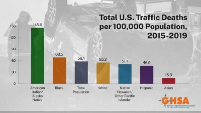
U.S. Traffic Fatalities Increased Most for Black Americans During the Pandemic
Two new reports confirm the racial disparities of traffic violence in the United States, revealing more proof about who stayed home during the pandemic, and who was forced to navigate the risks of the pandemic in public.
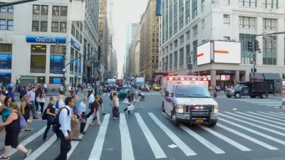
New York City Traffic Fatalities Pass 2019 Totals
The visions of a car-free utopia that might have seemed like a potential silver lining in March and April have given away to a tragic reality.
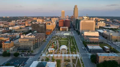
Downtown Omaha Planning for its Post-One-Way-Streets Era
The Omaha City Council has decided to reverse the transportation model adopted in the city in the 1950s, for the benefit of traffic safety and local retail activity.

Planetizen Federal Action Tracker
A weekly monitor of how Trump’s orders and actions are impacting planners and planning in America.

Map: Where Senate Republicans Want to Sell Your Public Lands
For public land advocates, the Senate Republicans’ proposal to sell millions of acres of public land in the West is “the biggest fight of their careers.”

Restaurant Patios Were a Pandemic Win — Why Were They so Hard to Keep?
Social distancing requirements and changes in travel patterns prompted cities to pilot new uses for street and sidewalk space. Then it got complicated.

Platform Pilsner: Vancouver Transit Agency Releases... a Beer?
TransLink will receive a portion of every sale of the four-pack.

Toronto Weighs Cheaper Transit, Parking Hikes for Major Events
Special event rates would take effect during large festivals, sports games and concerts to ‘discourage driving, manage congestion and free up space for transit.”

Berlin to Consider Car-Free Zone Larger Than Manhattan
The area bound by the 22-mile Ringbahn would still allow 12 uses of a private automobile per year per person, and several other exemptions.
Urban Design for Planners 1: Software Tools
This six-course series explores essential urban design concepts using open source software and equips planners with the tools they need to participate fully in the urban design process.
Planning for Universal Design
Learn the tools for implementing Universal Design in planning regulations.
Heyer Gruel & Associates PA
JM Goldson LLC
Custer County Colorado
City of Camden Redevelopment Agency
City of Astoria
Transportation Research & Education Center (TREC) at Portland State University
Camden Redevelopment Agency
City of Claremont
Municipality of Princeton (NJ)