


The National Highway Safety Administration released traffic safety data finding a huge spike in fatalities since the outset of the pandemic, but didn't mention the role of street design in traffic fatalities.
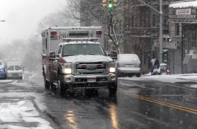
"The rate of roadway fatalities skyrocketed to 1.42 deaths per 100 million vehicle miles traveled in the second quarter of 2020, according to the National Highway Safety Administration’s just-released report," reports Kea Wilson.
The report makes officials news that has been apparent since the beginning of the pandemic: that drivers are more reckless and dangerous since stay-at-home orders and social distancing emptied roads of cars around the country.
The 1.42 deaths per 100 million vehicles miles traveled represents a 32 percent increase over the 1.08 deaths per 100 million vehicle miles traveled reported for the same period last year.
"With so many fewer cars on the road, the raw number of deadly crashes did decrease during the height of quarantine orders, but not by very much," writes Wilson. "NHTSA reports that 8,870 people lost their lives on U.S. roadways between April and June of this year — just a 3.3-percent decrease over the same period last year, despite declines of driving of as much as 94 percent in many areas of the country."
In an exclusive interview with Reuters, a spokesperson for the NHSTA blamed drivers for risky behavior, but Wilson expresses dismay that "the federal agency blamed the bloodshed on everything but bad road design."
FULL STORY: Road Fatality Rates Reach Highest Level in 15 Years

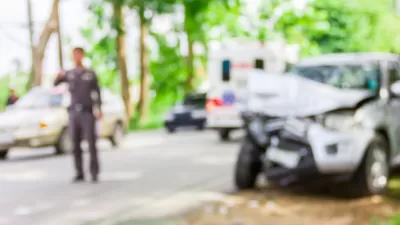
Traffic Fatalities Set Records as Pandemic-Era Road Carnage Shows No Signs of Stopping
An estimated 42,915 people died in automobile crashes in 2021, according to recent federal data. The increasing fatalities continue a trend that began with the outset of the pandemic.
Experts Fear a Permanent 'Arousal Breakout' on U.S. Roadways
The reckless and dangerous driving that has been a hallmark of the Covid-19 pandemic could become a more common, permanent feature of life in the United States.
The Most Complete Map of U.S. Pedestrian Risk Yet
New research published by the Journal of Transport and Land Use analyzes tens of thousands of pedestrian fatalities over 16 years in the United States.

Maui's Vacation Rental Debate Turns Ugly
Verbal attacks, misinformation campaigns and fistfights plague a high-stakes debate to convert thousands of vacation rentals into long-term housing.

Planetizen Federal Action Tracker
A weekly monitor of how Trump’s orders and actions are impacting planners and planning in America.

San Francisco Suspends Traffic Calming Amidst Record Deaths
Citing “a challenging fiscal landscape,” the city will cease the program on the heels of 42 traffic deaths, including 24 pedestrians.

Defunct Pittsburgh Power Plant to Become Residential Tower
A decommissioned steam heat plant will be redeveloped into almost 100 affordable housing units.

Trump Prompts Restructuring of Transportation Research Board in “Unprecedented Overreach”
The TRB has eliminated more than half of its committees including those focused on climate, equity, and cities.

Amtrak Rolls Out New Orleans to Alabama “Mardi Gras” Train
The new service will operate morning and evening departures between Mobile and New Orleans.
Urban Design for Planners 1: Software Tools
This six-course series explores essential urban design concepts using open source software and equips planners with the tools they need to participate fully in the urban design process.
Planning for Universal Design
Learn the tools for implementing Universal Design in planning regulations.
Heyer Gruel & Associates PA
JM Goldson LLC
Custer County Colorado
City of Camden Redevelopment Agency
City of Astoria
Transportation Research & Education Center (TREC) at Portland State University
Jefferson Parish Government
Camden Redevelopment Agency
City of Claremont