


Technology
High Tech Stores Provide New Leases on Life for High-End Malls
Big-name technology companies with retail stores, like Apple, Microsoft, and Tesla, have enabled many Class A malls to not just stay in business, but thrive. Record sales per square foot are flowing.

Mapping U.S. Highway Intensity
A new map from Mapbox visualizes traffic on all roads eligible for highway safety funds by combining data available through the Highway Performance Monitoring System on OpenStreetMap.
Private Cellphone Data and the Next Frontier of Urban Planning
A survey of the quickly broadening reach of data about the movement of traffic reveals the next step necessary to achieve congestion nirvana: unfettered access to private cell phone data.
Is the Waze Police-Tracking Feature a Threat to Public Safety?
The popular navigation app Waze includes a feature that rewards users for revealing the location of police officers. A debate over the public safety impacts of that feature is gaining traction, and some police officers want the feature removed.
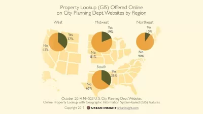
City Planning Department Technology Benchmarking Survey 2015
The following report surveys the current state of Internet technology as employed by the planning departments of over 500 cities in the United States.
An Interactive Map of California's Urban Water Use
California has commenced new water use reporting requirements, which the Pacific Institute has compiled into an interactive map and database to provide accessible evidence about where the state's water goes.
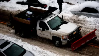
Pittsburgh Launches GPS-Enabled Snow Plow Tracker
Pittsburgh has a new web-based portal for residents to track snow removal operations as they happen. It's the latest example of a city allowing public access to the details of city operations during snowstorms.
Can Maine Follow Denmark to Energy Independence?
Visitors from small islands off the coast of Maine traveled to Samsø, a larger island off the coast of Denmark, to learn how to emulate its transformation into a model of renewable energy.
Lessons for the Real World in SimCity 4's Homeless Problem
Emanuel Maiberg discusses an ongoing crisis in a simulated version of reality familiar to many planners—i.e., the homelessness problem in SimCity 4.
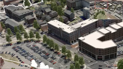
A Small Town's Game-Changing Approach to Mapping
Portsmoth, New Hampshire has created textured, 3D maps of its historic district to help illustrate development impacts during the approval process.
Uber Partnering with Boston to Establish National Data Sharing Model
After months of speculation and calls for transportation network companies to share data that might be helpful in refining the transportation systems of cities, Uber has announced a partnership with Boston that could do just that.
The First-Ever 'Ecological Land Units' Map of the World
A new web-based tool by the U.S. Geological Survey (USGS) and Esri allows users to "explore the ecological tapestry of the world."
Study Shows How Useful Twitter Data Can Be for Planners
The atlantalarry blog shares news of a study in the Engineering Applications of Artificial Intelligence journal that used gelocalized tweets to map out nightlife areas in Madrid, London, and Manhattan.
'Pop Up' Bus Startup Bridj Expands, Updates App
Bridj, a tech-enabled "pop up" bus service that first hit the road in June of 2014, has expanded of service and launched a new version of its app with significant operational changes.
The Spinlister App: 'Airbnb for Bikes'
A new app is part bikeshare and part Airbnb.
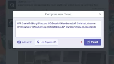
Editor's Picks: Top Twitter Feeds
Planetizen Managing Editor James Brasuell shares his favorite Twitter feeds.
Massachusetts Approves Initial Regulations for Transportation Network Companies
Transportation network companies like Uber and Lyft took a major step toward legal recognition in Massachusetts.

Uber and Lyft Are Dragging Traditional Taxi Companies Into the 21st Century
Rideshares like Uber and Lyft have been under attack for their brash approach to local regulations and laissez-faire pricing schemes, but they've also pushed traditional taxis to dramatically improve their service in a very short span of time.
Sign of the Times: Trulia Partnering with Uber
A new technology partnership between Trulia and Uber will allow house hunters to easily access a ride from Uber when they find a home they want to visit.
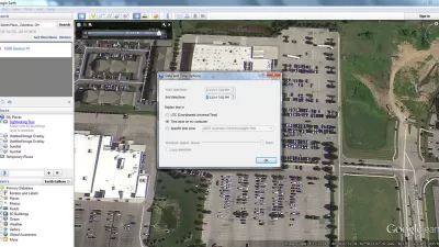
Using Google Earth to Understand Parking Utilization
As planners we use maps on a daily basis. This article shares how to find the date and time that a Google Earth image was taken, which can be helpful in undertaking site analysis and understanding parking utilization.
Urban Design for Planners 1: Software Tools
This six-course series explores essential urban design concepts using open source software and equips planners with the tools they need to participate fully in the urban design process.
Planning for Universal Design
Learn the tools for implementing Universal Design in planning regulations.
Heyer Gruel & Associates PA
JM Goldson LLC
Custer County Colorado
City of Camden Redevelopment Agency
City of Astoria
Transportation Research & Education Center (TREC) at Portland State University
Camden Redevelopment Agency
City of Claremont
Municipality of Princeton (NJ)


