


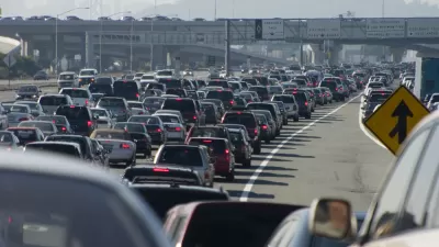
A survey of the quickly broadening reach of data about the movement of traffic reveals the next step necessary to achieve congestion nirvana: unfettered access to private cell phone data.
"The proliferation of granular data on automobile movement, drawn from smartphones, cab companies, sensors and cameras, is sharpening our sense of how cars travel through cities," according to a new post by Henry Grabar for Next City.
The article proceeds to whiz through a survey of the groundbreaking troves of data that have emerged in recent years, citing specific examples and explaining in common sense terms how the new data is changing the thinking of researchers, businesses, and government.
But even that data is only a percentage of the benefits available if individual cellphones are fully enabled to share data about traffic and mobility, according to Grabar. Grabar compares cellphones to taxi or municipal bus data in making this point: "Using individual cellphones would have a far greater impact. AirSage, which has exclusive rights to location data from two major U.S. wireless carriers, offers real-time, geographic information on one-third of Americans."
The catch, according to Grabar, is for Americans to willingly give up private data on their whereabouts.
FULL STORY: Would You Share Private Data for the Good of City Planning?

Failing to Account for Induced Traffic, Even When the Public Demands It
Induced traffic occurs when new highway capacity speeds up traffic, allowing travelers to drive further, increasing sprawl. A review of major highway project plans finds that most fail to accurately account for induced travel effects.
How Not to Measure Traffic Congestion, Redux
The 2015 Inrix Traffic Scorecard provides less useful information about traffic problems than previous editions, as discussed in this City Observatory Commentary.

Judge Extends NYC Congestion Pricing Through at Least June 9
A federal judge halted the Trump administration’s effort to kill the program, which remains in limbo as a lawsuit filed by the MTA moves forward.

Planetizen Federal Action Tracker
A weekly monitor of how Trump’s orders and actions are impacting planners and planning in America.

Congressman Proposes Bill to Rename DC Metro “Trump Train”
The Make Autorail Great Again Act would withhold federal funding to the system until the Washington Metropolitan Area Transit Authority (WMATA), rebrands as the Washington Metropolitan Authority for Greater Access (WMAGA).

The Simple Legislative Tool Transforming Vacant Downtowns
In California, Michigan and Georgia, an easy win is bringing dollars — and delight — back to city centers.

The States Losing Rural Delivery Rooms at an Alarming Pace
In some states, as few as 9% of rural hospitals still deliver babies. As a result, rising pre-term births, no adequate pre-term care and "harrowing" close calls are a growing reality.

The Small South Asian Republic Going all in on EVs
Thanks to one simple policy change less than five years ago, 65% of new cars in this Himalayan country are now electric.

DC Backpedals on Bike Lane Protection, Swaps Barriers for Paint
Citing aesthetic concerns, the city is removing the concrete barriers and flexposts that once separated Arizona Avenue cyclists from motor vehicles.
Urban Design for Planners 1: Software Tools
This six-course series explores essential urban design concepts using open source software and equips planners with the tools they need to participate fully in the urban design process.
Planning for Universal Design
Learn the tools for implementing Universal Design in planning regulations.
Smith Gee Studio
City of Charlotte
City of Camden Redevelopment Agency
City of Astoria
Transportation Research & Education Center (TREC) at Portland State University
US High Speed Rail Association
City of Camden Redevelopment Agency
Municipality of Princeton (NJ)