


The atlantalarry blog shares news of a study in the Engineering Applications of Artificial Intelligence journal that used gelocalized tweets to map out nightlife areas in Madrid, London, and Manhattan.
As Larry Felton Johnson explains, the data in a recent study are "useful in urban planning, because it gives a good sense of what large groups of people are doing from hour to hour in a specific city or region." According to the the atlantalarry post, planners should be able to see the broader impacts of specific information. Although the study "mentions night life in particular, where the data might give guidance into allocation of resources for cleanup and noise mitigation."
The study, titled "Spectral clustering for sensing urban land use using Twitter activity," is by Enrique and Vanessa Frías-Martínez, brother and sister computer science researchers at Telefonica Research and the University of Maryland (USA), respectively.
The Science Daily post about the study includes this quote from Enrique Frías-Martínez explaining why the use of data crowd-sourced from Twitter might improve traditional forms of community engagement employed by planners: "you can capture information on urban land use more efficiently and for a much larger number of people than with questionnaires. Moreover, this type of consultation, traditionally used until now in planning activities, are very costly and can cause problems due to the lack of accuracy of the answers."
FULL STORY: Analysis of tweets may be useful for urban planners

Researchers Pull Social Media Data to Track Migration
The limitations (and inaccuracies) of traditional data sources like the U.S. Census are well known, so researchers are looking social media to gather the data necessary to draw conclusions about societal movements.
Facebook's New Infographic: Where Are We 'Checking In'?
Tyler Falk reports on new data released by Facebook, mapping the top 5 "social landmarks" in 25 cities from Seoul to São Paulo.
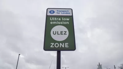
London Congestion Pricing Zone Has No Impact on Local Spending
The city’s cordon pricing scheme did not affect how much people spent at local businesses, new research finds.

Maui's Vacation Rental Debate Turns Ugly
Verbal attacks, misinformation campaigns and fistfights plague a high-stakes debate to convert thousands of vacation rentals into long-term housing.

Planetizen Federal Action Tracker
A weekly monitor of how Trump’s orders and actions are impacting planners and planning in America.

In Urban Planning, AI Prompting Could be the New Design Thinking
Creativity has long been key to great urban design. What if we see AI as our new creative partner?

Portland Raises Parking Fees to Pay for Street Maintenance
The city is struggling to bridge a massive budget gap at the Bureau of Transportation, which largely depleted its reserves during the Civd-19 pandemic.

Spokane Mayor Introduces Housing Reforms Package
Mayor Lisa Brown’s proposals include deferring or waiving some development fees to encourage more affordable housing development.

Houston Mayor Kills Another Bike Lane
The mayor rejected a proposed bike lane in the Montrose district in keeping with his pledge to maintain car lanes.
Urban Design for Planners 1: Software Tools
This six-course series explores essential urban design concepts using open source software and equips planners with the tools they need to participate fully in the urban design process.
Planning for Universal Design
Learn the tools for implementing Universal Design in planning regulations.
Gallatin County Department of Planning & Community Development
Heyer Gruel & Associates PA
JM Goldson LLC
City of Camden Redevelopment Agency
City of Astoria
Transportation Research & Education Center (TREC) at Portland State University
Jefferson Parish Government
Camden Redevelopment Agency
City of Claremont