


Portsmoth, New Hampshire has created textured, 3D maps of its historic district to help illustrate development impacts during the approval process.
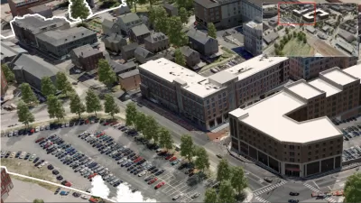
Rebecca Tuhus-Dubrow shares the story of how the small, historic community of Portsmouth, New Hampshire implemented innovative mapping software that shows how new buildings will fit into the town's historic fabric.
As Tuhus-Dubrow explains, Portsmouth shifted its use of technology to more aesthetic ends by using Tangram 3DS to create a 3D map of "nearly the entire historic district" of the town.
The goal of the maps, which were solicited by the city, is to enable architects, developers and the public to see how proposed buildings would look in context. Developers are, in fact, now required to show before-and-after images for major infill or redevelopment projects at planning meetings. The visuals are also available at a web portal so the public can see them at any time. You can zoom in and out, and see 360-degree views.
In the remainder of the article, Tuhus-Dubrow also explains the recent history of 3D mapping technology, first implemented by the Boston Redevelopment Authority, as well as some of the details about what makes Portsmouth's effort innovative.
FULL STORY: Modern Mapping Connects Historic Preservation and Planning


Placemaking in the Barrio: Conceptualizing Infill Development in Disenfranchised Communities
How one San Antonio neighborhood could approach sustainable revitalization while supporting the existing community and drawing on its rich and diverse history and cultural resources.

Maryland Passes New Vacancy Tax Law
The law allows local jurisdictions to set tax rates for vacant lots and properties to discourage speculation and stimulate development.

How Effective are Philadelphia’s Keystone Opportunity Zones?
The impacts of a tax break designed to create jobs, stimulate development, and reduce blight are proving hard to track.

Maui's Vacation Rental Debate Turns Ugly
Verbal attacks, misinformation campaigns and fistfights plague a high-stakes debate to convert thousands of vacation rentals into long-term housing.

Planetizen Federal Action Tracker
A weekly monitor of how Trump’s orders and actions are impacting planners and planning in America.

In Urban Planning, AI Prompting Could be the New Design Thinking
Creativity has long been key to great urban design. What if we see AI as our new creative partner?

King County Supportive Housing Program Offers Hope for Unhoused Residents
The county is taking a ‘Housing First’ approach that prioritizes getting people into housing, then offering wraparound supportive services.

Researchers Use AI to Get Clearer Picture of US Housing
Analysts are using artificial intelligence to supercharge their research by allowing them to comb through data faster. Though these AI tools can be error prone, they save time and housing researchers are optimistic about the future.

Making Shared Micromobility More Inclusive
Cities and shared mobility system operators can do more to include people with disabilities in planning and operations, per a new report.
Urban Design for Planners 1: Software Tools
This six-course series explores essential urban design concepts using open source software and equips planners with the tools they need to participate fully in the urban design process.
Planning for Universal Design
Learn the tools for implementing Universal Design in planning regulations.
planning NEXT
Appalachian Highlands Housing Partners
Mpact (founded as Rail~Volution)
City of Camden Redevelopment Agency
City of Astoria
City of Portland
City of Laramie