


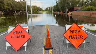
FEMA has redone official maps of flood-prone areas across the country, designating some as flood zones for the first time.
"The changes stem from the Federal Emergency Management Agency's multiyear plan to digitize its Flood Insurance Rate Maps to make them more accurate and easier to update.
New flood maps go into effect this month in 123 communities in Alabama, Georgia, Illinois, Kansas, Mississippi, North Carolina, South Carolina, Tennessee and Wisconsin. By 2010, about 92% of the population and 65% of the land in the USA will be covered by the maps, FEMA says.
The maps are the official record of the country's flood zones. The federal government requires properties in flood zones that have federally backed mortgages to carry flood insurance, FEMA spokesman Simon Chabel said. Mortgage companies also use the maps and can make flood insurance a condition for a loan."
FULL STORY: New high-tech FEMA maps redefine flood zones

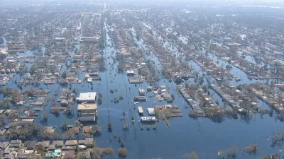
New Flood Maps Downplay Risks in New Orleans
Recently released flood maps created by FEMA for the city of New Orleans are receiving criticism for being 'overly optimistic' when it comes to risks posed by hurricanes and rising sea levels.
FEMA Resilience Program Cuts Grant Funding
The Building Resilient Infrastructure and Communities program funded projects from flood prevention to power station upgrades.
FEMA Suspends Flood Rebuilding Standard
The rule was designed to prevent the rebuilding of government-funded projects in areas prone to repeated floods.

Planetizen Federal Action Tracker
A weekly monitor of how Trump’s orders and actions are impacting planners and planning in America.

Map: Where Senate Republicans Want to Sell Your Public Lands
For public land advocates, the Senate Republicans’ proposal to sell millions of acres of public land in the West is “the biggest fight of their careers.”

Restaurant Patios Were a Pandemic Win — Why Were They so Hard to Keep?
Social distancing requirements and changes in travel patterns prompted cities to pilot new uses for street and sidewalk space. Then it got complicated.

Platform Pilsner: Vancouver Transit Agency Releases... a Beer?
TransLink will receive a portion of every sale of the four-pack.

Toronto Weighs Cheaper Transit, Parking Hikes for Major Events
Special event rates would take effect during large festivals, sports games and concerts to ‘discourage driving, manage congestion and free up space for transit.”

Berlin to Consider Car-Free Zone Larger Than Manhattan
The area bound by the 22-mile Ringbahn would still allow 12 uses of a private automobile per year per person, and several other exemptions.
Urban Design for Planners 1: Software Tools
This six-course series explores essential urban design concepts using open source software and equips planners with the tools they need to participate fully in the urban design process.
Planning for Universal Design
Learn the tools for implementing Universal Design in planning regulations.
Heyer Gruel & Associates PA
JM Goldson LLC
Custer County Colorado
City of Camden Redevelopment Agency
City of Astoria
Transportation Research & Education Center (TREC) at Portland State University
Camden Redevelopment Agency
City of Claremont
Municipality of Princeton (NJ)