


The city is continuing its investment in safety and accessibility improvements for transit riders, pedestrians, and cyclists.
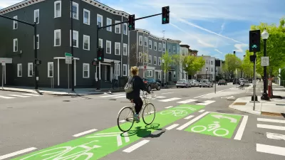
Writing for Houston Public Media, Adam Zuvanich outlines the city of Houston’s efforts to build better bike and pedestrian infrastructure and improve its public transit. The city has built 400 miles of bike lanes since passing its bike plan in 2017, and is expanding and improving its bus services and facilities. Zuvanich lists major projects in the works, including safety improvements on North Main Street and new bike lanes in Third Ward, among others.
While the Texas Department of Transportation (TxDOT) continues to widen freeways in the region, there are many ongoing projects involving the city, Harris County, Metropolitan Transit Authority of Harris County (METRO) and Houston Parks Board that are expanding transportation options for residents in the interests of access and equity, safety, economic growth and mitigating the impacts of climate change.
Improvements to Metro stations will include new and expanded crosswalks, accessibility ramps, and bus shelters. “As of last year, METRO also had improved about 2,500 of its 9,000 bus stops through its universal accessibility program, to make its services more accessible for Houstonians with disabilities.”
Gabe Cazares, executive director of LINK Houston, says he knows the changes won’t happen overnight. “That's why organizations like ours exist, to continue pushing every level of government to ensure they are protecting the interests of all people, not just vehicle owners.”
FULL STORY: How Houston will continue expanding transportation options in 2023


California Governor Signs Complete Streets Bill Into Law
The state’s transportation agency will be required to prioritize multimodal transportation infrastructure and improve transparency.

Houston Residents Respond to Mobility Questions
What could the city look like if budget and bureaucracy were no object?
NACTO Releases Updated Urban Bikeway Guide
The third edition of the nationally recognized road design guide includes detailed design advice for roads that prioritize safety and accessibility for all users.

Planetizen Federal Action Tracker
A weekly monitor of how Trump’s orders and actions are impacting planners and planning in America.

Map: Where Senate Republicans Want to Sell Your Public Lands
For public land advocates, the Senate Republicans’ proposal to sell millions of acres of public land in the West is “the biggest fight of their careers.”

Restaurant Patios Were a Pandemic Win — Why Were They so Hard to Keep?
Social distancing requirements and changes in travel patterns prompted cities to pilot new uses for street and sidewalk space. Then it got complicated.

DC Area County Eliminates Bus Fares
Montgomery County joins a growing trend of making transit free.

Platform Pilsner: Vancouver Transit Agency Releases... a Beer?
TransLink will receive a portion of every sale of the four-pack.

Toronto Weighs Cheaper Transit, Parking Hikes for Major Events
Special event rates would take effect during large festivals, sports games and concerts to ‘discourage driving, manage congestion and free up space for transit.”
Urban Design for Planners 1: Software Tools
This six-course series explores essential urban design concepts using open source software and equips planners with the tools they need to participate fully in the urban design process.
Planning for Universal Design
Learn the tools for implementing Universal Design in planning regulations.
Heyer Gruel & Associates PA
JM Goldson LLC
Custer County Colorado
City of Camden Redevelopment Agency
City of Astoria
Transportation Research & Education Center (TREC) at Portland State University
Camden Redevelopment Agency
City of Claremont
Municipality of Princeton (NJ)