


The Urbanist details on of the big bus rapid transit routes on the table in Seattle.
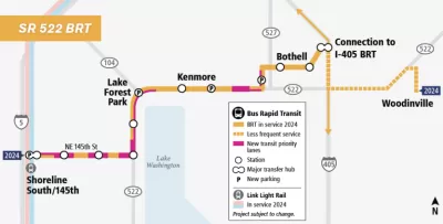
Sound Transit has launched the planning process for a proposed bus rapid transit (BRT) route along the State Route 522 corridor between Seattle and the suburbs of Lake Forest Park, Kenmore, Bothell, and Woodinville.
Stephen Fesler reports on the details of the proposed route of the BRT line:
The SR-522 BRT line is planned to run between the NE 145th St light rail station in Shoreline to Bothell with frequencies as high as every 10 minutes. Service on the line will be extended as far east as Woodinville, though with lower frequencies. The eight-mile line is expected to cost up to $386 million and serve 10,000 daily riders with travel times between Bothell and the light rail station around 28 minutes. Extended service to Woodinville would be closer to 45 minutes.
Other components of the proposed BRT route at this point in the development process include intentions to roll "high quality buses" with three doors, all-door boarding and alighting, and station platforms with shelters, branding, lighting, and real-time arrival information. The route will also connect with another planned BRT route along the I-405 corridor. Fesler provides a lot more details of what is known about the project so far, as well as the process of planning for the remainder of the project details, in the source article.
FULL STORY: SR-522 BRT Planning Is Underway


East Link Light Rail Plans Provoke Controversy in Seattle Suburb
A proposal to link local and regional buses with the East Link light rail expansion in Mercer Island, already under construction, threatens to boil over into the courtroom.
Seattle Rebrands its Planned Bus Rapid Transit System: Stride
Branding and bus rapid transit go hand in hand.
Sooner Rather Than Later: Support Builds for Eastside-Only Light Rail in Seattle
The Eastside Link light rail route, now known as Line 2, is delayed. A Sound Transit board officials is suggesting that some of the route can open soon, while the rest of the route is prepped to open later.

Planetizen Federal Action Tracker
A weekly monitor of how Trump’s orders and actions are impacting planners and planning in America.

Congressman Proposes Bill to Rename DC Metro “Trump Train”
The Make Autorail Great Again Act would withhold federal funding to the system until the Washington Metropolitan Area Transit Authority (WMATA), rebrands as the Washington Metropolitan Authority for Greater Access (WMAGA).

DARTSpace Platform Streamlines Dallas TOD Application Process
The Dallas transit agency hopes a shorter permitting timeline will boost transit-oriented development around rail stations.

San Francisco's School District Spent $105M To Build Affordable Housing for Teachers — And That's Just the Beginning
SFUSD joins a growing list of school districts using their land holdings to address housing affordability challenges faced by their own employees.

Car-Centric LA Suburb Looks to a Train-Oriented Future
City leaders in Rancho Cucamonga, the future western terminus of the Brightline West rail line to Las Vegas, want to reimagine the city as a transit-oriented, pedestrian-friendly community.

New Alaska Bitcoin Mine Would Burn as Much Energy as the State’s Largest Coal Plant
Fueled by “stranded” natural gas, the startup hopes to become the largest in the US, and to make Alaska an industry center.
Urban Design for Planners 1: Software Tools
This six-course series explores essential urban design concepts using open source software and equips planners with the tools they need to participate fully in the urban design process.
Planning for Universal Design
Learn the tools for implementing Universal Design in planning regulations.
Municipality of Princeton
Roanoke Valley-Alleghany Regional Commission
City of Mt Shasta
City of Camden Redevelopment Agency
City of Astoria
Transportation Research & Education Center (TREC) at Portland State University
US High Speed Rail Association
City of Camden Redevelopment Agency
Municipality of Princeton (NJ)