


San Francisco's red, transit-only lanes are a demonstration project. The lanes first appeared in 2013 and were supposed to last two years, with state and federal regulators to determine whether they would continue. The state evaluation began Dec. 6.
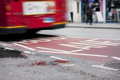
"Officials with the city’s Municipal Transportation Agency gained permission from state and federal authorities in 2012 to color some street pavement red to make transit-only lanes more visible and to try to persuade car and truck drivers to stay out of them," writes Michael Cabanatuan, transportation reporter for the San Francisco Chronicle.
The "red carpet lanes” debuted in 2013 and have expanded since then. "In total, 17 San Francisco streets with existing transit-only lanes were approved for the red pavement test, as well as three that didn’t have reserved bus lanes," adds Cabanatuan. "Not all of the stretches have yet been covered with red."
However, the program is a pilot in MTA's Transit Effectiveness Project, and while they have proven to be effective in improving transit service, they have also proven controversial, particularly with one car wash owner although there is no red lane by his business, yet.
[T]he experiment was supposed to last just two years, and involve periodic progress reports to the California Traffic Control Devices Committee and the Federal Highway Administration. The MTA’s first written report to the state agency, however, was not presented until [Dec. 6].
With no firm deadline, the test continued mostly unnoticed, at least until it got the attention of Glenn Urban, who owns a car wash with his brother on Geary Boulevard in the Richmond District where the MTA plans to install red transit-only lanes as part of a bus rapid transit project now being designed.
Urban fears that the red lanes will impact his business by confusing drivers, although they can cross them where permitted.
When they see them, they don’t know what to do, so they stay away,” Urban said. The MTA, he added, has “done little research on what this red paint means to businesses.”
Urban is by no means alone. Mission District merchants expressed similar concerns to Cabanatuan. “There are a lot of merchants that are not happy with all the changes on Mission Street,” said Phil Lesser, head of the Mission Merchants Association.
Urban made his case to the Caltrans' California Traffic Control Devices Committee at their Dec. 6 meeting in Sacramento. See agenda [PDF] #5: "Items under Experimentation: Request to experiment with Red Colored Transit-only Lanes. SFMTA- Present Draft Evaluation report..."
Federal evaluation expected in March, with final determination thereafter
After receiving the MTA report, CTCDC "allowed the experiment to continue and ordered up a final report to the federal government due in March, said Duper Tong, chief of the Caltrans office of traffic engineering and a committee member," reports Cabanatuan.
The report, which focused on the Third, Geary and O’Farrell lanes, concluded that the colored pavement kept more cars out of the transit lanes and reduced collisions. It also slowed traffic outside the transit-only lanes but sped up buses only some of the time.
In considering whether to make the red lanes permanent, state and federal traffic officials will put an emphasis on how effective the paint is at keeping cars out, whether it reduces collisions and how much it speeds up buses, Tong said.
Should regulators determine the red lanes have not been effective, the colorful bus-only lanes will be history.
=====================================================================================
Related on Planetizen:
- District DOT Rolls Out the Red Carpet for Bus Transit, June 22, 2016: Washington, D.C. is the latest place to find traffic lanes emblazoned with a bright red coat of paint to welcome transit while barring cars.
- San Francisco Transit-Only Lane Controversy Heating Up, June 17, 2016: Public opinion is split on the red transit-only lanes found around San Francisco.
- San Francisco's Red Transit-Only Lanes Improving Service, September 20, 2014: For years, San Francisco has set aside transit-only lanes. However, with a fresh coat of red paint, the city has seen significant service improvements.
- A Bold Addition to 'Transit-First' San Francisco Streets, March 18, 2014: In an effort to improve on-time performance of Muni, San Francisco has begun painting transit-only lanes...red.
FULL STORY: SF red transit lane beloved by riders, but merchants unhappy


FHWA Greenlights More Red Lanes for Buses in San Francisco
The Federal Highway Administration approved 50 applications of red transit-only lanes to be painted throughout San Francisco. Already used on four streets in a pilot program, the lanes have proven effective but are opposed by some business owners.
San Francisco’s Muni Ridership Grew in 2024
The system saw its highest ridership since before the Covid-19 pandemic, but faces a severe budget shortage in the coming year.
More Details of Bus Rapid Transit's Expanding Reach in San Francisco
The Geary bus corridor was the #1 pick for a subway according to a Muni survey, but commuters will have to settle for bus rapid transit. A milestone was reached when the San Francisco County Transportation Authority approved the design and EIR.

Planetizen Federal Action Tracker
A weekly monitor of how Trump’s orders and actions are impacting planners and planning in America.

San Francisco's School District Spent $105M To Build Affordable Housing for Teachers — And That's Just the Beginning
SFUSD joins a growing list of school districts using their land holdings to address housing affordability challenges faced by their own employees.

The Tiny, Adorable $7,000 Car Turning Japan Onto EVs
The single seat Mibot charges from a regular plug as quickly as an iPad, and is about half the price of an average EV.

With Protected Lanes, 460% More People Commute by Bike
For those needing more ammo, more data proving what we already knew is here.

In More Metros Than You’d Think, Suburbs are Now More Expensive Than the City
If you're moving to the burbs to save on square footage, data shows you should think again.

The States Losing Rural Delivery Rooms at an Alarming Pace
In some states, as few as 9% of rural hospitals still deliver babies. As a result, rising pre-term births, no adequate pre-term care and "harrowing" close calls are a growing reality.
Urban Design for Planners 1: Software Tools
This six-course series explores essential urban design concepts using open source software and equips planners with the tools they need to participate fully in the urban design process.
Planning for Universal Design
Learn the tools for implementing Universal Design in planning regulations.
Smith Gee Studio
City of Charlotte
City of Camden Redevelopment Agency
City of Astoria
Transportation Research & Education Center (TREC) at Portland State University
US High Speed Rail Association
City of Camden Redevelopment Agency
Municipality of Princeton (NJ)