


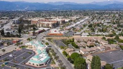
A coalition in Los Angeles County wants to reframe the debate about closing the gap in the 710 Freeway, asking Metro to look "beyond the 710"—and toward a multi-pronged, multimodal approach to transportation problems in the region.
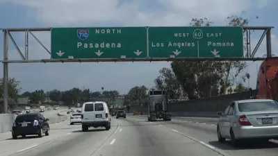
In the early 2000s, legal battles finally blocked a surface freeway extension across the 4.5-mile stretch where the I-710 was meant to connect to the I-210. This year, Caltrans and Los Angeles County Metropolitan Transportation Authority (Metro) released a draft EIR/EIS examining five other options, with Caltrans recommending an underground tunnel.
But several cities—particularly those in the proposed tunnel’s path—say the era of building freeways is over, and that Metro should instead study sustainable, "complete street" alternatives that alleviate regional traffic while benefiting local communities.
Glendale Mayor Ara Najarian—who serves on, and once chaired, the Metro board—co-chairs the Beyond the 710 coalition with South Pasadena City Council member Dr. Marina Khubesrian. In an interview with The Planning Report, they explained why they think a tunnel would be wrong for the area, and the benefits of a comprehensive "complete streets" solution instead.
For Khubesrian, a physician, one crucial factor is community health: According to the Air Quality Management District, the tunnel project could raise the risk of cancer by almost 15 times. The area, Khubesrian says, is already chillingly known as "the cancer corridor."
Additionally, the tunnel would cost several billion dollars, and cities worry it could become a drain on funding for other projects the region may need.
Beyond the 710 worked with transportation consulting firm Nelson\Nygaard to develop an alternative proposal—one that costs $705 million, and which consultant Paul Moore says addresses numerous problems felt by residents throughout the area.
The proposed bundle of solutions includes extending a Metro rail line, improving a north-south surface transit route, funding a regional bike plan, and taking steps to enhance pedestrian safety. As part of a strategy for travel demand management, it would subsidize transit passes for students in the corridor—which Moore says would eliminate more driving trips than the tunnel would carry.
The debate in the San Gabriel Valley has become so heated that several cities—including Glendale, South Pasadena, Burbank, and Pasadena—are looking into leaving the area’s Council of Governments and forming a new alliance, to receive separate funding and make its own transportation decisions.
For Mayor Najarian, this disagreement has revealed an important lesson around regional planning that he thinks should be recognized countywide:
"Communities most affected can’t just be one more vote in the decision-making process," he says. "They have to have a weighted and seriously accentuated voice… The stakes are much higher for cities and communities where projects are located. Decision-making cannot be based on a one-city-one-vote process."
Read more at The Planning Report.
FULL STORY: 'Beyond the 710' Coalition Adamantly Opposes Tunnel Alternative

Southern California Officials Slow to Accept Complete Streets
Proposed changes to the Los Angeles County Transportation Authority's highway program would allow local governments the flexibility to implement complete street elements with new projects. The proposition has been a surprisingly tough sell.
After a Failed Freeway Plan, Alternatives Prove Controversial
With plans to extend California's 710 Freeway off the table, cities in the path have been awarded funds for alternative road projects. But residents of San Marino aren't all on board.

Op-Ed: 'Public Mood' Has Turned Against Cars in Cities
A survey of recent planning decisions demonstrates that cities are no longer necessarily looking to more and bigger highways to solve their traffic problems.

Planetizen Federal Action Tracker
A weekly monitor of how Trump’s orders and actions are impacting planners and planning in America.

Maui's Vacation Rental Debate Turns Ugly
Verbal attacks, misinformation campaigns and fistfights plague a high-stakes debate to convert thousands of vacation rentals into long-term housing.

Restaurant Patios Were a Pandemic Win — Why Were They so Hard to Keep?
Social distancing requirements and changes in travel patterns prompted cities to pilot new uses for street and sidewalk space. Then it got complicated.

In California Battle of Housing vs. Environment, Housing Just Won
A new state law significantly limits the power of CEQA, an environmental review law that served as a powerful tool for blocking new development.

Boulder Eliminates Parking Minimums Citywide
Officials estimate the cost of building a single underground parking space at up to $100,000.

Orange County, Florida Adopts Largest US “Sprawl Repair” Code
The ‘Orange Code’ seeks to rectify decades of sprawl-inducing, car-oriented development.
Urban Design for Planners 1: Software Tools
This six-course series explores essential urban design concepts using open source software and equips planners with the tools they need to participate fully in the urban design process.
Planning for Universal Design
Learn the tools for implementing Universal Design in planning regulations.
Heyer Gruel & Associates PA
JM Goldson LLC
Custer County Colorado
City of Camden Redevelopment Agency
City of Astoria
Transportation Research & Education Center (TREC) at Portland State University
Jefferson Parish Government
Camden Redevelopment Agency
City of Claremont