


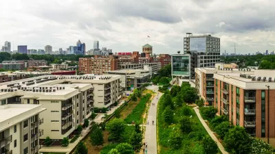
Famously far-flung Atlanta is finding a comforting psychic barrier in the BeltLine, a 45-mile greenbelt in the place of former railroad tracks. The city and developers are trying to make the urban core more functional and attractive.

As in many other cities, young adults in Atlanta are increasingly choosing to live in the urban core rather than in any number of the region's sprawling suburbs. Even so, the contrast between central Atlanta and its outskirts has not, historically, been as stark as those in other cities. Many downtown destinations, like the Underground Atlanta mall, have remained relatively lifeless because of low residential densities and un-walkable streets.
The region, though, is in the process of building 45 miles worth of walkable, bikeable urban infrastructure. When completed, the BeltLine, plus a series of parks, will create a loop around central Atlanta with a 2-4 mile radius connecting 45 neighborhoods and creating a new sense of place for the central city. It has already "proven itself a powerful tool for changing the way people think about Atlanta’s development.
So far, $775 million worth of development has taken place within a half-mile of just one of the segments of the BeltLine. Planners tout developments like the adaptive reuse of a 1925 Sears warehouse and the 138-acre mixed-use Atlanta Station development.
"It isn’t hard to see a geographic correlation between the location of this trend and the outline of the Atlanta BeltLine. Looping the center of the city with a series of paths and parks, it will, when fully completed, pass through 45 close-in neighborhoods that are all within a two- to four-mile radius of downtown. Even in its partially completed early stages, the BeltLine has proven itself a powerful tool for changing the way people think about Atlanta’s development."
FULL STORY: Urbanising Atlanta

Surveying the Results of 150 Years of Persistent Growth in Atlanta
The American Institute of Architects will visit Atlanta this year, a month after the 150th anniversary of the end of the Civil War. What should we know about the city as it exists today?

Atlanta Changes Beltline Rail Plan
City officials say they are committed to building rail connections, but are nixing a prior plan to extend the streetcar network.
Beltline Surpasses Annual Affordable Housing Goal
The Atlanta Beltline agency is actively working to prevent the displacement of longtime residents along the trail system, where property values are rising rapidly.

Planetizen Federal Action Tracker
A weekly monitor of how Trump’s orders and actions are impacting planners and planning in America.

San Francisco's School District Spent $105M To Build Affordable Housing for Teachers — And That's Just the Beginning
SFUSD joins a growing list of school districts using their land holdings to address housing affordability challenges faced by their own employees.

The Tiny, Adorable $7,000 Car Turning Japan Onto EVs
The single seat Mibot charges from a regular plug as quickly as an iPad, and is about half the price of an average EV.

Seattle's Plan for Adopting Driverless Cars
Equity, safety, accessibility and affordability are front of mind as the city prepares for robotaxis and other autonomous vehicles.

As Trump Phases Out FEMA, Is It Time to Flee the Floodplains?
With less federal funding available for disaster relief efforts, the need to relocate at-risk communities is more urgent than ever.

With Protected Lanes, 460% More People Commute by Bike
For those needing more ammo, more data proving what we already knew is here.
Urban Design for Planners 1: Software Tools
This six-course series explores essential urban design concepts using open source software and equips planners with the tools they need to participate fully in the urban design process.
Planning for Universal Design
Learn the tools for implementing Universal Design in planning regulations.
Smith Gee Studio
City of Charlotte
City of Camden Redevelopment Agency
City of Astoria
Transportation Research & Education Center (TREC) at Portland State University
US High Speed Rail Association
City of Camden Redevelopment Agency
Municipality of Princeton (NJ)