


The American Institute of Architects will visit Atlanta this year, a month after the 150th anniversary of the end of the Civil War. What should we know about the city as it exists today?
Ahead of the 2015 AIA National Convention, to be held this May in Atlanta, Rebecca Burns introduces Atlanta's current explosive growth and urban renaissance by first noting the metropolitan area's sprawling growth patters, driven by the automobile, since the beginning of the 20th century.
Writes Burns:
"With no natural boundaries, metro Atlanta sprawled, fueled by a population that doubled from 2 million in 1980 to 4 million in 2000, and has continued to surge in this millennium. With 28 counties spread over 8,400 square miles, today’s Atlanta metro region occupies a larger land mass than the combined states of Connecticut and Rhode Island."
But the pendulum has swung, according to Burns:
"Frustrated with sitting in traffic, development patterns driven by subdivisions, and a car-centric culture, a growing number of metro Atlantans are going back to the future by seeking out the compact development patterns of the city’s early history."
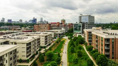
For evidence of Atlanta's newest transformation, Burns discusses the BeltLine and a walkable suburban development called Avalon, located 27 miles north of Downtown Atlanta.
The article also includes a long set of images, renderings, and site studies showing the transformation of the BeltLine into an active recreation and transportation corridor.
FULL STORY: AIA Design: Welcome to the Boomtown


Atlanta Beltline Symbolizes Efforts to Reverse Tide of Sprawl
Famously far-flung Atlanta is finding a comforting psychic barrier in the BeltLine, a 45-mile greenbelt in the place of former railroad tracks. The city and developers are trying to make the urban core more functional and attractive.

Atlanta Changes Beltline Rail Plan
City officials say they are committed to building rail connections, but are nixing a prior plan to extend the streetcar network.
Beltline Surpasses Annual Affordable Housing Goal
The Atlanta Beltline agency is actively working to prevent the displacement of longtime residents along the trail system, where property values are rising rapidly.

Maui's Vacation Rental Debate Turns Ugly
Verbal attacks, misinformation campaigns and fistfights plague a high-stakes debate to convert thousands of vacation rentals into long-term housing.

Planetizen Federal Action Tracker
A weekly monitor of how Trump’s orders and actions are impacting planners and planning in America.

In Urban Planning, AI Prompting Could be the New Design Thinking
Creativity has long been key to great urban design. What if we see AI as our new creative partner?

King County Supportive Housing Program Offers Hope for Unhoused Residents
The county is taking a ‘Housing First’ approach that prioritizes getting people into housing, then offering wraparound supportive services.

Researchers Use AI to Get Clearer Picture of US Housing
Analysts are using artificial intelligence to supercharge their research by allowing them to comb through data faster. Though these AI tools can be error prone, they save time and housing researchers are optimistic about the future.

Making Shared Micromobility More Inclusive
Cities and shared mobility system operators can do more to include people with disabilities in planning and operations, per a new report.
Urban Design for Planners 1: Software Tools
This six-course series explores essential urban design concepts using open source software and equips planners with the tools they need to participate fully in the urban design process.
Planning for Universal Design
Learn the tools for implementing Universal Design in planning regulations.
planning NEXT
Appalachian Highlands Housing Partners
Mpact (founded as Rail~Volution)
City of Camden Redevelopment Agency
City of Astoria
City of Portland
City of Laramie