


The existing bike path on the eastern span of the Bay Bridge meets an abrupt dead end, though it will be extended to Yerba Buena Island next summer. Plans are underway to extend the path to San Francisco, but it won't be cheap.
"Bay Bridge officials are looking for a cheaper way to build a two-mile trail along the western span after a study estimated the project would cost a whopping $400 million to $500 million," writes Dennis Cuff of the Contra Costa Times. Arup North America, Ltd won the $10 million contract for the engineering study to develop a less costly design for the bicycle-pedestrian path.
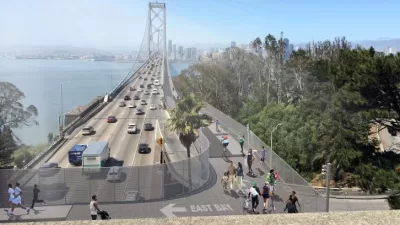
Up to four alternatives will be examined in detail for a 12-foot-wide steel deck path separated from auto traffic lanes along the 2-mile-long west span between San Francisco and Yerba Buena Island.
Two days earlier, Cuff wrote that the "Bay Area Toll Authority, the regional agency that collects toll money to operate the Bay Bridge and six other state-owned spans," indicated that the current estimate was "too much."
"It's just not fundable within our current constraints," said John Goodwin, a spokesman for the toll authority. "The plan is to look at alternatives to shrink that estimate and come up with something that is buildable and fundable.
The new $6.4 billion eastern span, from Oakland to Yerba Buena Island, opened in September, 2013. The bike path could not extend fully to Yerba Buena Island "until workers demolish a portion of the old bridge," wrote Justin Berton of the San Francisco Chronicle shortly before the new span opened.
"Renee Rivera, executive director of Bike East Bay [formerly the East Bay Bicycle Coalition], said the study was 'a crucial next step to get to a fundable plan for a west span path' and was confident the price can be pared down," writes Michael Cabanatuan of the San Francisco Chronicle.
[Hat tip to MTC-ABAG Library's News Headlines]
FULL STORY: Bay Bridge officials approve $10 million study on adding path to west span

Dreaming of a Bike Path on the Western Span of the Bay Bridge
Arup released some very exciting renderings of a proposed pedestrian and bike path on one of the most picturesque and heavily-trafficked spans on the West Coast.
Planning Underway for New Bay Bridge Bike Path, and a Second Transbay BART Tube
In a distant and expensive future, there are two new ways to get across the San Francisco Bay without a car. One will have a much better view.
Bay Bridge Construction Woes Raise Earthquake Safety Concerns
One of the reasons for the $6.4 billion investment in the new eastern span of the Bay Bridge was to ensure the safety of the bridge in the even of a large earthquake.

Planetizen Federal Action Tracker
A weekly monitor of how Trump’s orders and actions are impacting planners and planning in America.

Map: Where Senate Republicans Want to Sell Your Public Lands
For public land advocates, the Senate Republicans’ proposal to sell millions of acres of public land in the West is “the biggest fight of their careers.”

Restaurant Patios Were a Pandemic Win — Why Were They so Hard to Keep?
Social distancing requirements and changes in travel patterns prompted cities to pilot new uses for street and sidewalk space. Then it got complicated.

Platform Pilsner: Vancouver Transit Agency Releases... a Beer?
TransLink will receive a portion of every sale of the four-pack.

Toronto Weighs Cheaper Transit, Parking Hikes for Major Events
Special event rates would take effect during large festivals, sports games and concerts to ‘discourage driving, manage congestion and free up space for transit.”

Berlin to Consider Car-Free Zone Larger Than Manhattan
The area bound by the 22-mile Ringbahn would still allow 12 uses of a private automobile per year per person, and several other exemptions.
Urban Design for Planners 1: Software Tools
This six-course series explores essential urban design concepts using open source software and equips planners with the tools they need to participate fully in the urban design process.
Planning for Universal Design
Learn the tools for implementing Universal Design in planning regulations.
Heyer Gruel & Associates PA
JM Goldson LLC
Custer County Colorado
City of Camden Redevelopment Agency
City of Astoria
Transportation Research & Education Center (TREC) at Portland State University
Camden Redevelopment Agency
City of Claremont
Municipality of Princeton (NJ)