


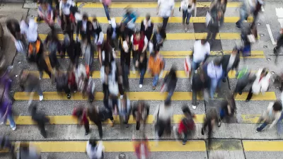
Jane E. Brody reports on the safety features New York City has instituted as part of an ambitious effort to completely re-engineer city streets.
As the numbers of pedestrians and cyclists in New York City have risen, a remarkable thing has happened, "the number of traffic-related deaths on city streets fell last year to the lowest level in a century, declining 40 percent since 2001."
Brody attributes these statistics to a plan-in-progress being led by the city's transportation commissioner, Janette Sadik-Khan, to re-engineer the city's streets with safety features such as, "pedestrian plazas, well-marked crosswalks, bike lanes (both segregated and shared with vehicles) and timed traffic signals that enable pedestrians to better judge their ability to cross streets safely."
According to Brody, "The city is also enhancing enforcement of traffic laws, with more summonses for drivers who ignore stop signs, sail through red lights, and talk or text on a handheld device while driving. But as Ms. Sadik-Khan acknowledges, this is only the beginning; a lot more must be done to make the city streets safer for people who wish to navigate them under their own steam."
FULL STORY: Personal Health: Giving City Streets Built-In Safety Features

Where Cities Have Helped Walkers
Laura Laker surveys efforts to make cities more walkable, from Melbourne's converted alleys to Guangzhou's 60-mile ecological corridor.
To Control Health Costs, Build Sidewalks
Each month new research emerges linking public health with the built environment. Yet just a small fraction of healthcare spending goes toward reducing our exposure to unhealthy environments. Under the Affordable Care Act, that could soon change.
What More 'Livable Streets' Could Mean for New York
This article from The New York Observer looks at how New York City might be different with more "livable streets".

Planetizen Federal Action Tracker
A weekly monitor of how Trump’s orders and actions are impacting planners and planning in America.

Map: Where Senate Republicans Want to Sell Your Public Lands
For public land advocates, the Senate Republicans’ proposal to sell millions of acres of public land in the West is “the biggest fight of their careers.”

Restaurant Patios Were a Pandemic Win — Why Were They so Hard to Keep?
Social distancing requirements and changes in travel patterns prompted cities to pilot new uses for street and sidewalk space. Then it got complicated.

Platform Pilsner: Vancouver Transit Agency Releases... a Beer?
TransLink will receive a portion of every sale of the four-pack.

Toronto Weighs Cheaper Transit, Parking Hikes for Major Events
Special event rates would take effect during large festivals, sports games and concerts to ‘discourage driving, manage congestion and free up space for transit.”

Berlin to Consider Car-Free Zone Larger Than Manhattan
The area bound by the 22-mile Ringbahn would still allow 12 uses of a private automobile per year per person, and several other exemptions.
Urban Design for Planners 1: Software Tools
This six-course series explores essential urban design concepts using open source software and equips planners with the tools they need to participate fully in the urban design process.
Planning for Universal Design
Learn the tools for implementing Universal Design in planning regulations.
Heyer Gruel & Associates PA
JM Goldson LLC
Custer County Colorado
City of Camden Redevelopment Agency
City of Astoria
Transportation Research & Education Center (TREC) at Portland State University
Camden Redevelopment Agency
City of Claremont
Municipality of Princeton (NJ)