


In this op-ed, the executive director of the San Francisco County Transportation Authority makes a case for congestion pricing in the City, though he is quick to indicate the SFCTA is only studying the concept to see if it could be applied there.
"There is no high-tech solution to congested streets; no magic bullet. We need a concerted set of actions to ensure that San Francisco's growth will be sustainable and that it will not degrade our quality of life", writes José Luis Moscovich, the executive director of the San Francisco County Transportation Authority.
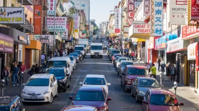
"This is a study to establish whether the concept could work here, not a proposal to implement it tomorrow. According to the technical analysis, the proposed plan that reduces the most congestion while causing the least negative impacts, would price access to the entire northeast quadrant of the city only between 6 and 9 a.m. and from 3 to 6 p.m. There would be no pricing at all midday, in evenings, or on weekends.
The revenue generated through congestion pricing would be used to increase transit service in and out of the pricing zone. The Van Ness Avenue and Geary Boulevard bus upgrades to bus rapid transit lines are an example.
Our habit of driving everywhere for every purpose is largely responsible for traffic congestion, and for climate change impacts. Congestion pricing can help us break out of that cycle. With the best supply of transit this side of the Hudson River, nobody will be left stranded in San Francisco."
Thanks to Melissa Hippard
FULL STORY: Open Forum: Congestion pricing is a solution for San Francisco

Congestion Pricing Scheme Up for Discussion in San Francisco
The public is providing feedback for the idea of a congestion pricing scheme that could charge as much as $12 to drive into Downtown San Francisco.
Congestion Pricing Under Discussion in San Francisco
An expanding number of major U.S. cities are exploring the idea of charging drivers to drive into certain heavily trafficked parts of town. San Francisco is the most recent to explore the idea of congestion pricing (also known as cordon pricing).
Social Equity Cited in Veto of California Road Pricing Bill
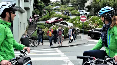
Gov. Gavin Newsom vetoed a unique road pricing bill due to concerns that charging a fee would limit access to driving on two blocks of Lombard Street, a popular tourist attraction in San Francisco that is severely congested.

Planetizen Federal Action Tracker
A weekly monitor of how Trump’s orders and actions are impacting planners and planning in America.

Map: Where Senate Republicans Want to Sell Your Public Lands
For public land advocates, the Senate Republicans’ proposal to sell millions of acres of public land in the West is “the biggest fight of their careers.”

Restaurant Patios Were a Pandemic Win — Why Were They so Hard to Keep?
Social distancing requirements and changes in travel patterns prompted cities to pilot new uses for street and sidewalk space. Then it got complicated.

Albuquerque Route 66 Motels Become Affordable Housing
A $4 million city fund is incentivizing developers to breathe new life into derelict midcentury motels.

DC Area County Eliminates Bus Fares
Montgomery County joins a growing trend of making transit free.

Platform Pilsner: Vancouver Transit Agency Releases... a Beer?
TransLink will receive a portion of every sale of the four-pack.
Urban Design for Planners 1: Software Tools
This six-course series explores essential urban design concepts using open source software and equips planners with the tools they need to participate fully in the urban design process.
Planning for Universal Design
Learn the tools for implementing Universal Design in planning regulations.
Heyer Gruel & Associates PA
JM Goldson LLC
Custer County Colorado
City of Camden Redevelopment Agency
City of Astoria
Transportation Research & Education Center (TREC) at Portland State University
Camden Redevelopment Agency
City of Claremont
Municipality of Princeton (NJ)