


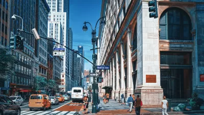
The plan to reimagine Manhattan’s Third Avenue to make it safer for pedestrians and cyclists is being applauded by advocates, but some say the city should go further to provide more space for multimodal transportation.

A New York City street that some call “an inhospitable and dangerous traffic sewer” will soon be reimagined as a multimodal corridor, per a Streetsblog NYC article by Julianne Cuba.
After months of advocacy from local pols and activists — and a shiny spread in New York Magazine showcasing what a reimagined current seven-lane Third Avenue could be — the Department of Transportation on Wednesday night unveiled its plans to a Manhattan Community Board 8 panel to take away two lanes of moving traffic in order to make room for a protected bike lane and designated bus lane on the corridor between E. 59th and E. 96th streets.
According to Cuba, “The plan, which also includes taking away parking spaces near intersections to allow for pedestrian islands and shorter crossing times, will not only help cyclists, but also pedestrians and the more than 50,000 bus riders daily, who currently suffer from exhaustingly slow commutes on the more than 150 buses that traverse the thoroughfare.”
While approving of the new changes, some advocates want the city to install additional protective bike infrastructure and wider sidewalks, with the article indicating that “it’s well documented that the existing protected bike lanes on First and Second avenues are already overcrowded and in need of widening.”
Cuba notes that the project is expected to break ground next year, and plans for the rest of Third Avenue are yet to be finalized.
FULL STORY: Manhattan Panel Cheers City’s Third Ave. Redesign (Though Some Wish it Was Bolder)

NYC Streets Plan Remains Largely on Paper
For the second year in a row, the city failed to meet legally required targets for building protected bike lanes and bus lanes.

New York City Plans Street Safety Projects as Congestion Pricing Nears
With congestion pricing projected to reduce the number of cars entering Manhattan, NYCDOT plans to repurpose street space to build more pedestrian and bike infrastructure.
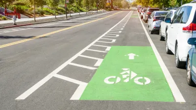
Why Bike Lanes Are Good: An Explainer for the US Transportation Secretary
Sean Duffy says there’s no evidence that bike lanes have benefits. Streetsblog — and federal agencies’ own data — beg to differ.

Planetizen Federal Action Tracker
A weekly monitor of how Trump’s orders and actions are impacting planners and planning in America.

Maui's Vacation Rental Debate Turns Ugly
Verbal attacks, misinformation campaigns and fistfights plague a high-stakes debate to convert thousands of vacation rentals into long-term housing.

Restaurant Patios Were a Pandemic Win — Why Were They so Hard to Keep?
Social distancing requirements and changes in travel patterns prompted cities to pilot new uses for street and sidewalk space. Then it got complicated.

In California Battle of Housing vs. Environment, Housing Just Won
A new state law significantly limits the power of CEQA, an environmental review law that served as a powerful tool for blocking new development.

Boulder Eliminates Parking Minimums Citywide
Officials estimate the cost of building a single underground parking space at up to $100,000.

Orange County, Florida Adopts Largest US “Sprawl Repair” Code
The ‘Orange Code’ seeks to rectify decades of sprawl-inducing, car-oriented development.
Urban Design for Planners 1: Software Tools
This six-course series explores essential urban design concepts using open source software and equips planners with the tools they need to participate fully in the urban design process.
Planning for Universal Design
Learn the tools for implementing Universal Design in planning regulations.
Heyer Gruel & Associates PA
JM Goldson LLC
Custer County Colorado
City of Camden Redevelopment Agency
City of Astoria
Transportation Research & Education Center (TREC) at Portland State University
Jefferson Parish Government
Camden Redevelopment Agency
City of Claremont