


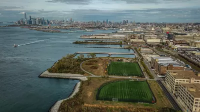
Improving streets in Sunset Park by removing cobblestones and aging train tracks has created a controversy between historic preservation and the need for safe bike and walking facilities and other streetscape improvements.
The streetscape improvement plan, which includes removing "swaths of the neighborhood’s cobblestone streets and railways," is included in New York City Economic Development Corporation's (NYCEDC) "estimated $37 million Sunset Park Infrastructure Project" that was the subject of a Brooklyn community board meeting on April 8, report Jaime DeJesus and Meaghan McGoldrick for the Brooklyn Daily Eagle.
That has railroad buffs and neighborhood boosters concerned about erasing part of the neighborhood’s history.
“The presence of cobblestone in the maritime area is iconic,” said Sunset Park resident and founder of Friends of Sunset Park Maria Roca, who was hoping to see a recovery or reuse plan that would “keep the cobblestones as part of the decorative mix.”
“They should definitely preserve the cobblestones and rails for several reasons,” said Bob Diamond, president of the Brooklyn Historic Railroad Association. “It’s part of the history of the area. Industry City was primarily serviced by rails, and pulling it out is like gutting the history of the neighborhood.”
Industry City is a $1 billion waterfront redevelopment of what used to be called Bush Terminal, "a historic intermodal shipping, warehousing, and manufacturing complex and the largest multi-tenant industrial property in the United States," according to Wikipedia.
Need for bike and pedestrian safety
"The Sunset Park Infrastructure Project is the result of a 2009 study, said Thomas Colavecchio, technical director for AKRF Environment, Planning and Engineering Consultants, the project’s lead designer," add DeJesus and McGoldrick.
“It was determined that there was a severe deficiency in infrastructure,” he said, “so the goal of the project was to make it safer for both pedestrians and vehicles, to improve the uneven road service and, overall, to promote businesses in the area," said Thomas Colavecchio, technical director for AKRF Environment, Planning and Engineering Consultants, the project’s lead designer.
“It’s very difficult for pedestrians to walk in this area,” he said, calling the current streets “decrepit.” [See Google maps image photo (jpg) in article.]
Colin Mixson, reporting for the Brooklyn Paper, observed that "[t]he roughly block-long bike lane — which will be installed alongside an expanded sidewalk, and separated from cars by a line of trees — will not link with any existing paths for cyclists, although the plan is to eventually connect it to the Brooklyn Greenway Initiative."
The Brooklyn Eagle article includes 35 slides [Scribd document] showing maps, photos, images and renderings by ARKF, which led the environmental review for the replacement of the Tappan Zee bridge, now named for former Gov. Mario Cuomo; Phase 1 of the Second Avenue Subway, and is now working on Phase 2 (96th Street to 125th Street).
Not all the train tracks will be removed though, as New York New Jersey Rail travels through the area to access the South Brooklyn Marine Terminal, transporting freight cars from Jersey City via barge, and train traffic is anticipated to increase, thanks to another NYEDC infrastructure investment.
Another significant part of the streetscape improvement plan includes planting more than 120 new streets trees in the project area, including Industry City and the South Brooklyn Marine Terminal.
Correspondent's note: While unable to locate NYCEDC's Sunset Park Infrastructure Project, here is there Sunset Park Vision Plan.
Related:
-
Is a New Cobblestone a Better Cobblestone? March 31, 2013In Brooklyn's Dumbo neighborhood, NYCDOT is looking to replace the area's historic cobblestones with artificially aged new ones to improve accessibility and bike-friendliness.
FULL STORY: City plans to remove rails and cobblestones along Sunset Park waterfront

New York City to Reduce Truck Emissions by Investing in Freight Rail Infrastructure
The Big Apple may claim the nation's highest public transit ridership, but it ranks well below average in its use of freight rail. Two small short line railroads are at the center of a $100 million investment to reduce truck reliance.
Controversial Rezoning for Industry City Mega-Project Finally Withdrawn in New York City
A controversial summer has finally claimed the grand ambitions for a waterfront site in Sunset Park, Brooklyn.
A Planning Showdown in New York City
The proposal to rezone the Industry City redevelopment area in the Sunset Park neighborhood of Brooklyn has won a key approval, but a controversial showdown in the City Council still awaits.

Planetizen Federal Action Tracker
A weekly monitor of how Trump’s orders and actions are impacting planners and planning in America.

Congressman Proposes Bill to Rename DC Metro “Trump Train”
The Make Autorail Great Again Act would withhold federal funding to the system until the Washington Metropolitan Area Transit Authority (WMATA), rebrands as the Washington Metropolitan Authority for Greater Access (WMAGA).

DARTSpace Platform Streamlines Dallas TOD Application Process
The Dallas transit agency hopes a shorter permitting timeline will boost transit-oriented development around rail stations.

Renters Now Outnumber Homeowners in Over 200 US Suburbs
High housing costs in city centers and the new-found flexibility offered by remote work are pushing more renters to suburban areas.

The Tiny, Adorable $7,000 Car Turning Japan Onto EVs
The single seat Mibot charges from a regular plug as quickly as an iPad, and is about half the price of an average EV.

Supreme Court Ruling in Pipeline Case Guts Federal Environmental Law
The decision limits the scope of a federal law that mandates extensive environmental impact reviews of energy, infrastructure, and transportation projects.
Urban Design for Planners 1: Software Tools
This six-course series explores essential urban design concepts using open source software and equips planners with the tools they need to participate fully in the urban design process.
Planning for Universal Design
Learn the tools for implementing Universal Design in planning regulations.
Municipality of Princeton
Roanoke Valley-Alleghany Regional Commission
City of Mt Shasta
City of Camden Redevelopment Agency
City of Astoria
Transportation Research & Education Center (TREC) at Portland State University
US High Speed Rail Association
City of Camden Redevelopment Agency
Municipality of Princeton (NJ)