


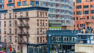
The High Line has a chance to add the role of civic connector to its list of plaudits.
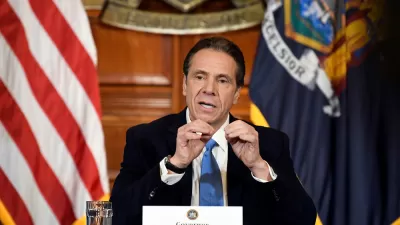
Mihir Zaveri and Daniel E. Slotnik report: "Gov. Andrew M. Cuomo said on Sunday that the High Line will be extended to connect to the newly opened Moynihan Train Hall, a project that he said help spur development in the surrounding neighborhoods and boost an economy facing a deep crisis because of the pandemic."
The Moynihan Train Hall opened on January 1, but already these plans promise to connect the newer facility to one of the most recognizable symbols of contemporary New York City.
The proposed link between the High Line and the new train station will create another access point for the station: "A 1,200-foot elevated walkway will connect the existing High Line at 30th Street to a pedestrian path at Manhattan West, a mixed used development adjacent to the train hall," according to the article.
The Moynihan connection isn't the High Line extension plan in the works by the state of New York. " The state is also eyeing another possible expansion of the High Line to connect it north to Pier 76 on West 38th Street, where Mr. Cuomo wants to turn a Police Department tow pound into another park. The existing High Line travels 1.45 miles from 34th Street south to Gansevoort Street in the Meatpacking District," report Zaveri and Slotnik.
The article references questions raised about spending priorities during the pandemic and aftermath. Gov. Cuomo explained how the state will finance the project.
"Mr. Cuomo, acknowledging that the state was facing severe financial difficulties because of the pandemic, said that its portion of the cost would come from infrastructure funds that could not be used to help address budget shortfalls. He said the state was also expecting aid from the federal government for infrastructure projects after Joseph R. Biden Jr. becomes president."
FULL STORY: $60 Million High Line Expansion to Connect Park to Moynihan Train Hall

Massive, Expensive Redevelopment of Midtown Manhattan Proposed
New York Governor Cuomo's State of the State speeches last week included an ambitious proposal for a large-scale redevelopment project on Manhattan's west side, adjacent to Penn Station.
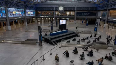
New York's Moynihan Train Hall Opens to the Public
The spacious, glass-ceilinged hall brings much-needed breathing room to the nation's busiest train station.
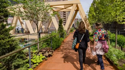
High Line-Moynihan Connector Opens in New York City
Two footbridges now link the High Line park to the most recent expansion of the Penn Station complex, the Moynihan Train Hall.

Planetizen Federal Action Tracker
A weekly monitor of how Trump’s orders and actions are impacting planners and planning in America.

Map: Where Senate Republicans Want to Sell Your Public Lands
For public land advocates, the Senate Republicans’ proposal to sell millions of acres of public land in the West is “the biggest fight of their careers.”

Restaurant Patios Were a Pandemic Win — Why Were They so Hard to Keep?
Social distancing requirements and changes in travel patterns prompted cities to pilot new uses for street and sidewalk space. Then it got complicated.

Platform Pilsner: Vancouver Transit Agency Releases... a Beer?
TransLink will receive a portion of every sale of the four-pack.

Toronto Weighs Cheaper Transit, Parking Hikes for Major Events
Special event rates would take effect during large festivals, sports games and concerts to ‘discourage driving, manage congestion and free up space for transit.”

Berlin to Consider Car-Free Zone Larger Than Manhattan
The area bound by the 22-mile Ringbahn would still allow 12 uses of a private automobile per year per person, and several other exemptions.
Urban Design for Planners 1: Software Tools
This six-course series explores essential urban design concepts using open source software and equips planners with the tools they need to participate fully in the urban design process.
Planning for Universal Design
Learn the tools for implementing Universal Design in planning regulations.
Heyer Gruel & Associates PA
JM Goldson LLC
Custer County Colorado
City of Camden Redevelopment Agency
City of Astoria
Transportation Research & Education Center (TREC) at Portland State University
Camden Redevelopment Agency
City of Claremont
Municipality of Princeton (NJ)