


Raise your hand if you envisioned a transportation network optimized to full efficiency by navigation apps.
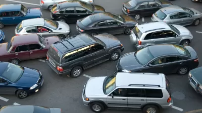
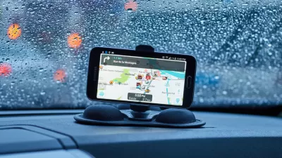
Navigation apps are allowing people to make more selfish decisions while driving, spreading traffic and congestion more evenly throughout the grid. Alexis C. Madrigal's explanation of this troubling outcome of navigation apps like Waze commences with a discussion of selfishness.
In the pre-mobile-app days, drivers’ selfishness was limited by their knowledge of the road network. In those conditions, both simulation and real-world experience showed that most people stuck to the freeways and arterial roads. Sure, there were always people who knew the crazy, back-road route, but the bulk of people just stuck to the routes that transportation planners had designated as the preferred way to get from A to B.
Now, however, a new information layer is destroying the nudging infrastructure that traffic planners built into cities. Commuters armed with mobile mapping apps, route-following Lyft and Uber drivers, and software-optimized truckers can all act with a more perfect selfishness.
A new study by researchers at UC Berkeley’s Institute of Transportation Studies inspires this discussion of a "vastly overlooked" problem. Here's Madrigal's summary of the findings of that study: "In some scenarios, traffic-beating apps might work for an individual, but make congestion worse overall. And autonomous vehicles, touted as an answer to traffic-y streets, could deepen the problem."
Alexandre Bayen, director of UC Berkeley’s Institute of Transportation Studies, is also on video discussing the study's findings, and more about what navigation apps mean for the future of traffic and congestion in cities.
FULL STORY: The Perfect Selfishness of Mapping Apps

Are Traffic Apps More a Problem Than a Solution?
The companies behind navigation apps say they want to decrease congestion in cities. But a tool that is essentially designed to help individuals isn’t going to provide a collective benefit.

Judge Extends NYC Congestion Pricing Through at Least June 9
A federal judge halted the Trump administration’s effort to kill the program, which remains in limbo as a lawsuit filed by the MTA moves forward.

NYC Congestion Pricing Continues to Show Positive Results
While the Trump administration attempts to revoke the program’s federal approval, congestion pricing continues to reduce traffic, speed up bus travel times, and improve air quality in Manhattan.

Planetizen Federal Action Tracker
A weekly monitor of how Trump’s orders and actions are impacting planners and planning in America.

Map: Where Senate Republicans Want to Sell Your Public Lands
For public land advocates, the Senate Republicans’ proposal to sell millions of acres of public land in the West is “the biggest fight of their careers.”

Restaurant Patios Were a Pandemic Win — Why Were They so Hard to Keep?
Social distancing requirements and changes in travel patterns prompted cities to pilot new uses for street and sidewalk space. Then it got complicated.

Platform Pilsner: Vancouver Transit Agency Releases... a Beer?
TransLink will receive a portion of every sale of the four-pack.

Toronto Weighs Cheaper Transit, Parking Hikes for Major Events
Special event rates would take effect during large festivals, sports games and concerts to ‘discourage driving, manage congestion and free up space for transit.”

Berlin to Consider Car-Free Zone Larger Than Manhattan
The area bound by the 22-mile Ringbahn would still allow 12 uses of a private automobile per year per person, and several other exemptions.
Urban Design for Planners 1: Software Tools
This six-course series explores essential urban design concepts using open source software and equips planners with the tools they need to participate fully in the urban design process.
Planning for Universal Design
Learn the tools for implementing Universal Design in planning regulations.
Heyer Gruel & Associates PA
JM Goldson LLC
Custer County Colorado
City of Camden Redevelopment Agency
City of Astoria
Transportation Research & Education Center (TREC) at Portland State University
Camden Redevelopment Agency
City of Claremont
Municipality of Princeton (NJ)