


Caltrans hopes to build two 14-mile high-occupancy toll lanes on Hwy 101 in San Mateo County, one of the region's most congested corridors that lacks carpool lanes. The $534 million project would begin construction in 2019.
Samantha Weigel reports for the San Mateo Daily Journal on a Dec. 11 public meeting [pdf] in San Mateo hosted by the state Department of Transportation (Caltrans) "as part of the drafting of the environmental document on which comments will be accepted through Jan. 19."
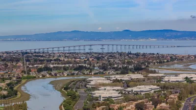
A map [png] of the area, along with fact sheets, presentations and the draft environmental impact report, released Nov. 20, are available on the Caltrans webpage, "SM 101 - Managed Lanes Project (MLP)." [SM stands for San Mateo County]. One new toll lane in each direction would start where the existing carpool lane bends at Whipple Avenue in Redwood City and go 14 miles north to the intersection with Interstate 380 in San Bruno just north of the San Francisco International Airport.
Reactions from the public were starkly different from a public meeting held on Dec. 7 in Colorado Springs to discuss a similar proposal by the Colorado Department of Transportation to widen an 18-mile stretch of Interstate 25 with one toll lane in each direction. Attendees largely expressed their outrage at having to pay to use the lane additions.
In San Mateo, "[a]ttendees were largely inquisitive," according to Weigel, though she does mention negative comments from prior meetings — that the express lane would benefit mainly wealthy drivers, although they would be free to 3+ carpools, hence the term high-occupancy toll (HOT) lanes, clean-air vehicles and motorcycles, or "that the additional space would be better utilized by extending popular mass transit such as BART along Highway 101."
Caltrans had good news regarding the need for additional space required for the express lane. Their engineering design shows that the project "will primarily stay within the state’s existing right-of-way and not require acquisition of any homes or businesses," writes Weigel.
Squeezing in space to widen the freeway includes narrowing some lanes from 12 feet to 11 feet, connecting existing auxiliary lanes while replacing heavily used ones, and relocating soundwalls in some areas. The project requires some right-of-way acquisition in San Mateo and Burlingame [confined to street frontage.]
The Daily Journal viewed this development favorably in their Nov. 22 editorial on the project.
While the verdict is out on toll roads since they benefit those who can afford them, creating a lane for buses [largely Google and other tech buses and shuttles] and carpools seems largely acceptable since there are already those on the highway lumbering along usually in the fast lane.
It would also provide a benefit to SamTrans, which is looking to expand its service along the highway...
The City/County Association of Governments and the San Mateo County Transportation Authority are partnering with Caltrans. It isn't clear, though, who would operate the lanes when completed, anticipated in the spring of 2019, as the Bay Area already has three operators:
- Metropolitan Transportation Commission
- Alameda County Transportation Commission
- Santa Clara Valley Transportation Commission
One attendee at the San Mateo meeting referenced Monday's article in the San Francisco Chronicle on the profitability of the I-580 Express Lanes in the East Bay.
“I read in the paper what happened with 580 and they’re just making [money] hand over fist with that and it seems to be working. So I think it would work here,” said Anne Merics, who has lived in Burlingame for more than four decades
However, most motorists actually pay to use those lanes, as noted by Planetizen, unlike the other two Bay Area express lane corridors where most vehicles either have clean-air stickers or qualify as carpools.
FULL STORY: Caltrans looks to fast-track managed lanes


Managed Lanes Coming to the San Francisco Peninsula
State and county officials gathered on Friday to celebrate the start of a $514 million project to convert carpool lanes to express lanes and connect auxiliary lanes to make for a lane addition. The 32-mile project on Highway 101 opens in 2022.
Converting a Freeway Lane to a Toll Lane: No Easy Task!
The San Mateo County Transportation Authority wants to extend its new express toll lanes north to the San Francisco border. The two build options are widening Highway 101 or converting an existing lane in each direction. One is essentially illegal.

Tollways for Sacramento?
Road pricing terminology can be confusing, particularly since Californians see so little of it. For example, a Sacramento TV station calls proposed express lanes on Interstate 80 from Solano County to Sacramento a ‘tollway.’

Planetizen Federal Action Tracker
A weekly monitor of how Trump’s orders and actions are impacting planners and planning in America.

Chicago’s Ghost Rails
Just beneath the surface of the modern city lie the remnants of its expansive early 20th-century streetcar system.

San Antonio and Austin are Fusing Into one Massive Megaregion
The region spanning the two central Texas cities is growing fast, posing challenges for local infrastructure and water supplies.

Since Zion's Shuttles Went Electric “The Smog is Gone”
Visitors to Zion National Park can enjoy the canyon via the nation’s first fully electric park shuttle system.

Trump Distributing DOT Safety Funds at 1/10 Rate of Biden
Funds for Safe Streets and other transportation safety and equity programs are being held up by administrative reviews and conflicts with the Trump administration’s priorities.

German Cities Subsidize Taxis for Women Amid Wave of Violence
Free or low-cost taxi rides can help women navigate cities more safely, but critics say the programs don't address the root causes of violence against women.
Urban Design for Planners 1: Software Tools
This six-course series explores essential urban design concepts using open source software and equips planners with the tools they need to participate fully in the urban design process.
Planning for Universal Design
Learn the tools for implementing Universal Design in planning regulations.
planning NEXT
Appalachian Highlands Housing Partners
Mpact (founded as Rail~Volution)
City of Camden Redevelopment Agency
City of Astoria
City of Portland
City of Laramie