


Satellite Imagery

Satellite, Launched Into Space Earlier This Month, to Measure Urban Heat Island Effect
A new satellite, currently residing on the International Space Station and scheduled for deployment in January, will measure and map the urban heat island effect of seven U.S. cities.

View the Smoke from the California Fires From Satellite
The National Oceanic and Atmospheric Administration has been making the most of its celestial perch to illustrate the scale of the fires currently burning in Southern California.
Using Satellite Imagery, This AI Traces Urban Wealth
Penny is an artificial intelligence program that detects affluence from space. It also lets users experiment with how different visual forms affect its perception of an area's wealth.
Borders From Above Are More Than Just Lines On A Map
International borders viewed from above show how different patterns of political, urban and agricultural development often collide.

What the Growth of D.C. Looked Like From Space
A history of growth and expansion is visible to the naked eye with photos covering a wide breadth of the planet and just a few short years.
Friday Eye Candy: Full-Color, HD Videos Taken from Space
For the first time, full-color videos of the earth's surface will be made available to the public, with added options for paying customers. The imagery comes from two cameras on the International Space Station.

Looking for Inspiration? Try a Daily Dose of a Satellite's Perspective
Here's a strange idea that just might work: viewing the planet from afar might offer the perspective necessary to care for and protect our place in the universe.
Mapbox's Landsat-Live Presents Satellite Imagery in Near-Real Time
Until last week, the seasons never changed on satellite image software. But Mapbox's Landsat-Live program shares clear images of the Earth's surface in near-real time.

Friday Eye Candy: Time-Lapse Shows How Rivers Meander
"No man ever steps in the same river twice, for it's not the same river and he's not the same man." -Heraclitus, as quoted by Plato in Cratylus.
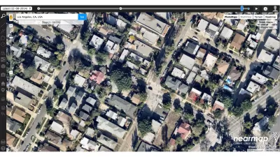
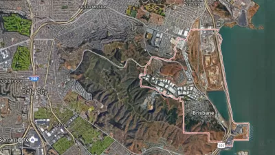
An Aerial Photography Tool for Planners
File under tools for the tool kit: Jarrett Walker of Human Transit shares details about Nearmap, an aerial photography tool that serves as a helpful alternative to Google Earth.
The New Whistleblower: Using Satellite Images to Spot Environmental Damage
West Virginia-based SkyTruth is culling satellite and aerial images to blow the whistle on unreported damage to the environment.
Stunning Photos of Earth From Space
A collection of satellite photos reveals the planet's beauty and vulnerability from threats such as desertification, sprawl, and pollution.
Can an Upstart Mapmaker Beat Google and Microsoft at Their Own Game?
Glenn Fleishman profiles MapBox, whose 30 employees are taking on the big boys in the development of interactive street and satellite maps. The company is working with Charlie Loyd to develop "the most beautiful, clean map ever made."
India Encourages Monster Master Planning Effort
Planners in search of work might want to consider looking in India. As Nate Berg reports, the Indian government is hoping a new technology initiative will catalyze master planning efforts in 7,935 cities and towns across the country.
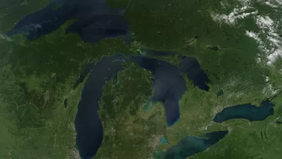
Our Changing Landscapes, as Seen From Orbit
Earlier this week we brought you stunning images of global urban growth as captured by Landsat, NASA's longest running satellite imagery program. These images capture the dramatic changes to some of America's natural landscapes.
Google Earth Reveals Un-Permitted Pools
A town in New York has been using satellite imagery from Google Earth to identify illegally-built pools.
Watching Urban Change Via Satellite
Recent earthquake response efforts in Haiti showed how comparing satellite imagery could help to identify physical changes in the damaged country and assist rescue workers. That same sort of imagery could play a similar role for urban planners.
NASA Says Agriculture Is Draining Groundwater in California
NASA satellite imagery reveals that two of California's main groundwater sources are being rapidly depleted by agriculture and exurban development.
Finding Ancient Cities Below the Surface
This slideshow form Popular Science takes a step-by-step look at how to detect and uncover ancient buried settlements from satellite imagery.
Urban Design for Planners 1: Software Tools
This six-course series explores essential urban design concepts using open source software and equips planners with the tools they need to participate fully in the urban design process.
Planning for Universal Design
Learn the tools for implementing Universal Design in planning regulations.
planning NEXT
Appalachian Highlands Housing Partners
Mpact (founded as Rail~Volution)
City of Camden Redevelopment Agency
City of Astoria
City of Portland
City of Laramie


