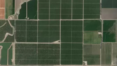
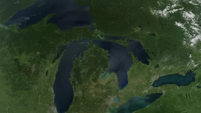
Here's a strange idea that just might work: viewing the planet from afar might offer the perspective necessary to care for and protect our place in the universe.
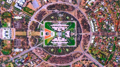
Anyone who has ever poured over maps of locations near or far understands how increasing the elevation of a vantage point can yield surprising revelations. Space-age technology now offers novel and surprising perspectives—new territory explored by the Daily Overview website. With a large archive of crisp, colorful satellite images, updated daily, the Daily Overview provides steady doses of vistas on built environments both familiar and exotic—often at the same time.
Over a year after Planetizen published a post introducing Daily Overview, we checked in with the site's founder, Benjamin Grant, to discuss the inspiration for his hard work on the site and the inspiration he hopes planners and urban designers find in this collection of overhead perspectives of the worlds we have created on the Earth.
[Ed's note: The interview has been lightly edited for clarity.]
What inspired you to launch the Daily Overview project? What were you hoping to achieve when you first started the project?
Grant: The project officially started in December of 2013. For me, the story goes back a little bit further than that. It starts with a conversation I had with a close friend's father, who asked me what I thought the answer was to the environmental crisis—in terms of, how can you get people to care about global warming and climate change and all those problems. And at the time, I had no real answer for him. I told him I'd think about it and get back to him. Ultimately, when I did get back to him, I said I think there needs to be a cognitive shift in people's minds so that they think about the planet differently. Because of the way we think about it now, it's kind of hard to see the big picture. I had no idea what that cognitive shift would be or how it would occur.
About six months after that, a friend sent me a video called "Overview," which is put together by a group called Planetary Collective. In the video they describe this idea called the "Overview Effect," which is a phenomenon reported by astronauts who spend a lot of time in outer space. When they have the opportunity to look down at the planet and see it as a whole, see it floating with a "backdrop of infinity," as they say, they get a new understanding of what it means to be a human being, to be alive, and to share one planet all together. In this video, they talk about how the borders that you see from outer space are not the borders we see on a globe or on a map, they are human constructed borders, they're highways, they're the Great Wall of China, they're factories, they are massive cities at night. So it struck me that you can provide this overview using the technology that we have with satellites, and with satellite image databases, to inspire this phenomenon in people who will not have the opportunity to go into outer space. We cannot all be so lucky.

So Daily Overview does that on a small scale once a day—in a very digestible amount of information that can be informative, quick to read, and quick to understand. A key point is that all the images that I’ve captured and I have focused on throughout the course of the project as a result have all been things that humans have created—for good and for bad. I’m not saying what you are seeing is our destruction of the planet—just what we are doing as humans. Making people more aware of that, ties in more nicely of the Overview Effect.
How are you sourcing these images? How is it that you can find such high quality images?
Grant: I partnered with a company called Digital Globe, which is a satellite company based out of Colorado. You see their images when you go on to Google Maps, Apple Maps, or Google Earth, and you go into the satellite view. They have been doing this for a number of years, and have this wonderful database of high-resolution images. I start there, and most of the images I capture start with the research looking up historical examples of great urban planning, finding those cities, and then exploring to see what's there. Then I go to that database and focus on that specific area.
Which do you find more of, better or worse? How do you balance between those two choices?
Grant: The project has been as successful as it has because I found things that are aesthetically pleasing. In terms of ultimately getting back to the core mission of the project and showing how we've impacted the planet, the ones that are most successful, be it for good or bad, are the ones that have the aesthetic ability to pull people back and capture their attention. One image that comes to mind is the Dadaab refugee camp in Kenya. It's this extremely colorful, highly organized systematic image, with a massive grid structure of refugee tents. When you see it—if you saw it hanging on somebody’s wall—you might think, "Wow, those colors are beautiful, it’s an extremely beautiful image." But once you learn what it is, you get a greater understanding and awareness and it changes the power of the image entirely.
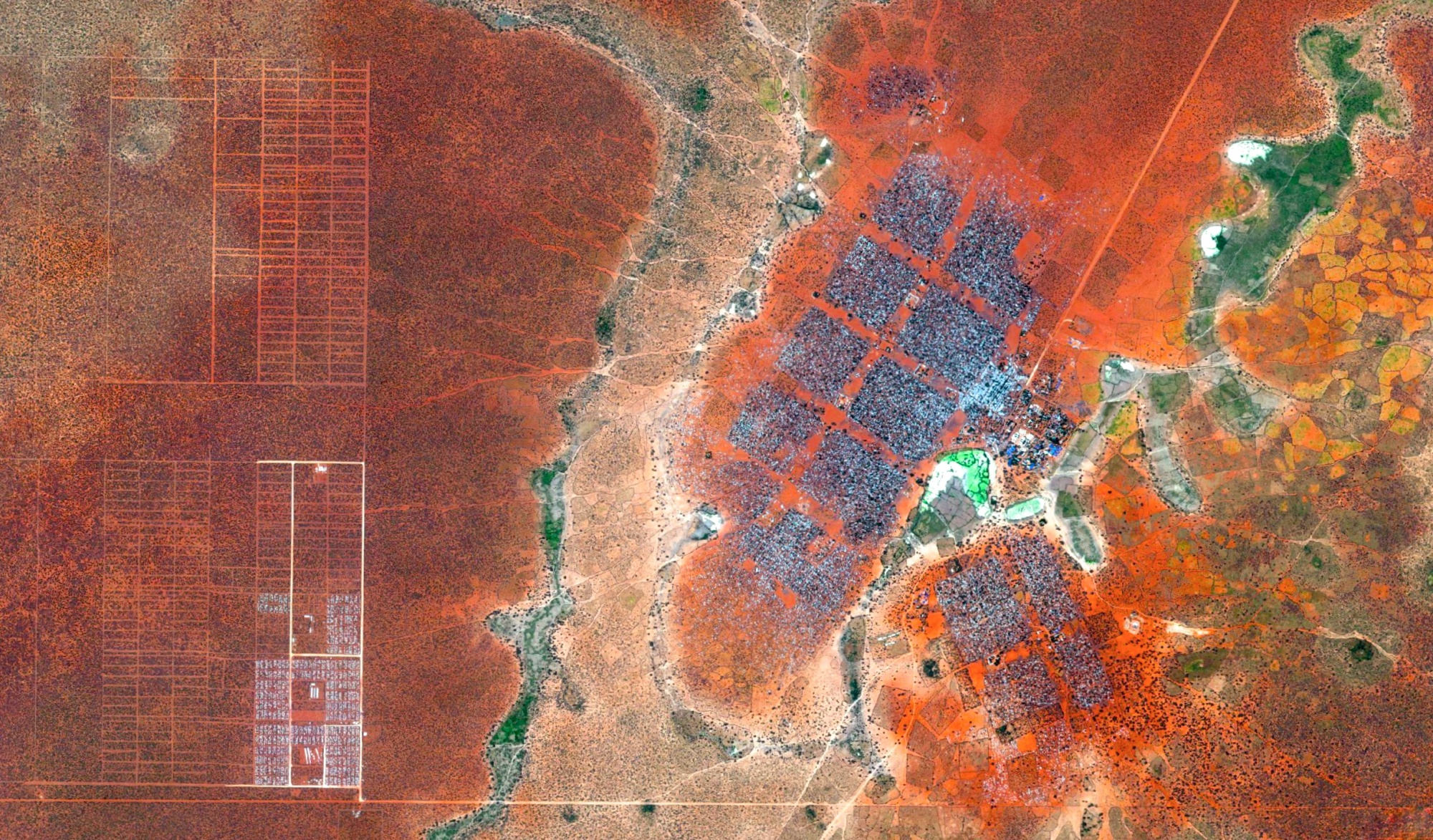
To cope with the growing number of displaced Somalis arriving at Dadaab Refugee Camp in northern Kenya, the UN has begun moving people into a new area called the LFO Extension (the grids seen at left). The camp is already the largest in the world with more than 400,000 registered refugees. (Image and text courtesy of Daily Overview.)
Your question is interesting within certain themes that I’ve come across. For energy, for example, you can find good and bad. You can find renewable energy and solar power factories, or you can find coal factories. I've been doing this every single day for almost a year and a half, what I’m discovering is that I'll probably never run out of material. Just doing a search for coal factories in the United States is endless. It is important to find a balance between the good and the bad, and ultimately that's up to me to make sure I am doing both, and presenting a fair perspective of what's going on.
As I've started grouping the images, it's given me a retrospective on what I’ve done so far, what kind of gaps I have, and what can help as I go forward to present a nice balance.
That's interesting: the idea that aesthetics, which is subjective and can be visceral, could enable a greater intellectual understanding of a situation or a place.
Grant: There is also another level when you show people something they are very familiar with from a completely different angle or a completely different perspective. Shipping containers is one that comes to mind. I’m sure I’ve gone by hundreds of ports in my life. But when you see that mass in perfect organization on a large scale it's mind blowing. Recently, I did the Pyramids of Giza, which is something that everyone knows, but flattening it out and seeing it differently added a kind of twist to the site.
What do you think the effect of this Overview Effect perspective is for your audience? Do you find these images make humans seem or feel more powerful on individual or cultural scales? Or do you find it can bring about feelings of insignificance or being overwhelmed at the scale of everything we have created?
Grant: What's most amazing for me to see is connection across cultures, which is ultimately, what I hope to accomplish with the project. Of the site's followers on Instagram, only about 35 percent are located in the United States. For me, to see people in the comments exchanging ideas from across countries, and across even continents, is powerfully connecting back to the core mission of the project. There is a kind of idea exchange and awareness. People who may be focused on their everyday life are seeing another part of the world, another place, or some historical area they didn't know existed. There is something to that.

I know how powerful the project is to me, and it's interesting that people take from it often what is closest to them. As an example, the project has covered been looked at as a design perspective, looking at these images as aesthetically pleasing and as an interesting way to see the world. People see it as a way making art out of the landscape that we have created or as a way of viewing the planet from an urban planning perspective.
These are ideas that people are studying. There are problems they are trying to solve. Viewing it this way can be helpful, can be inspiring, and can help people change the way they think about their jobs or the problems they are trying to solve.
You are focusing on the built environment and the creation of humans—does that mean no natural landscapes at all?
I can probably name most of the on the fingers on my hands. I've found some human connection to natural landscapes. For example, when you look at an image of Niagara Falls, you can see the tour boats coming up close to it. Or the grand prismatic string of Yellowstone National Park, where we've constructed boardwalks so humans can go up close and look at nature. One more example is the Antarctic ice shelf. Some people make an argument that there's not human impact, but this particular ice shelf is melting faster than ever from carbon emissions. So you don't necessarily see the actual human impact, but it's there in a lot of people's minds.
Are there perspectives that natural landscapes offer than built environments don't? Do you ever feel like you're missing a chance to find meaning by focusing only on built environments?
That's an interesting question. I remember just when I started capturing these images, I shared them with a few friends and I was tempted to do completely natural landscapes, and I think to guide the project and make it more cohesive I decided to only show unnatural landscapes. Maybe that's something I could explore later—there's so much left to see.
Are there any other editorial considerations that contribute to your choices about which images end up on the site that might be of interest to a planning- and design-interested audience?
There is a need to create geographic diversity—covering all the continents and making sure not to focus too exclusively on one country, mixing it up, and keeping a global perspective.
From an urban planning perspective, it's interesting that because of the amount of time Digital Globe has been collecting satellite images, you can see changes over time. For example sprawl, in places like Las Vegas, you can use to time-lapse images to see the city growing out.
You can learn a lot about places from this perspective—in looking at the layout and how historically the city has been built, for example, comparing New York to Paris to Barcelona. New York with its simple grid structure versus Paris with its diagonal radiating avenues and Barcelona, which has the Eixample district of buildings, with central courtyards and octagonal streets around that. They are beautiful images, but they also say a lot about the cultures of these cities and the people who live there.

It's amazing when people respond to these images and say, "I've been there many times, but I had no idea it looked like this."
Daily Overview is interesting to think about relative to the concept of sousveillance, as opposed to surveillance. Where surveillance allows dominant powers to monitor individuals and the public, sousveillance allows the public and individuals to turn the cameras back on those in power. Obviously people are concerned about the surveillance capabilities of satellites. For instance, it's always a bit concerning to use Google Satellite to look at your street and see your car parked out in front of your house. But from the other perspective, satellites allows us to look in on the impacts of large corporations or large-scale central planning efforts like highways or water supply infrastructure. Which side of the line between surveillance and sousveillance do you think this project comes down on?
There have been a number of times when I've stumbled on a corporate landscape, for example, salt evaporation ponds in the San Francisco Bay. A massive corporation called Cargill is running a massive red pond in the San Francisco Bay. I don't know if they would have any problem with that image—these are images that literally with the Internet could access via Google. In a way, the site is just calling attention to them.

Another example that comes to mind is beef production in the United States. Another artist focused on this perspective, but sometimes those places are illegal to photograph from the ground, and this makes it possible to look at them. They haven’t blurred it out.
As satellite images become more widespread, I could see corporations having a problem with them and requesting that they be blurred out, either with the satellite provider or with Google. I'm not necessarily showing people things that are secret or are a major problem. I can absolutely see why corporations might have a problem with it, but so far, I haven't come across that problem. It will be interesting to see what happens.
You mentioned that you hope the Daily Overview inspires people, but can you elaborate? In a perfect world, what do you hope readers get from your website?
For people looking to optimize their plans or their designs to be best suited to a particular place or a particular culture, having a knowledge of what's out there, beyond what you know or what you've studied, can be inspiring and can inform the decisions you make in the future. That inspiration can come from learning about things that have worked or things that haven't worked or things that are beautiful or things that are ugly. All of that, I think, can be influential and powerful in terms of working and adapting for the future.
I know don't specifically what your readers would take from one image to the next, but I think people should take what's most important and what's most meaningful to them and put it toward their work.


Planetizen Federal Action Tracker
A weekly monitor of how Trump’s orders and actions are impacting planners and planning in America.

Map: Where Senate Republicans Want to Sell Your Public Lands
For public land advocates, the Senate Republicans’ proposal to sell millions of acres of public land in the West is “the biggest fight of their careers.”

Restaurant Patios Were a Pandemic Win — Why Were They so Hard to Keep?
Social distancing requirements and changes in travel patterns prompted cities to pilot new uses for street and sidewalk space. Then it got complicated.

Platform Pilsner: Vancouver Transit Agency Releases... a Beer?
TransLink will receive a portion of every sale of the four-pack.

Toronto Weighs Cheaper Transit, Parking Hikes for Major Events
Special event rates would take effect during large festivals, sports games and concerts to ‘discourage driving, manage congestion and free up space for transit.”

Berlin to Consider Car-Free Zone Larger Than Manhattan
The area bound by the 22-mile Ringbahn would still allow 12 uses of a private automobile per year per person, and several other exemptions.
Urban Design for Planners 1: Software Tools
This six-course series explores essential urban design concepts using open source software and equips planners with the tools they need to participate fully in the urban design process.
Planning for Universal Design
Learn the tools for implementing Universal Design in planning regulations.
Heyer Gruel & Associates PA
JM Goldson LLC
Custer County Colorado
City of Camden Redevelopment Agency
City of Astoria
Transportation Research & Education Center (TREC) at Portland State University
Camden Redevelopment Agency
City of Claremont
Municipality of Princeton (NJ)


