


The National Oceanic and Atmospheric Administration has been making the most of its celestial perch to illustrate the scale of the fires currently burning in Southern California.
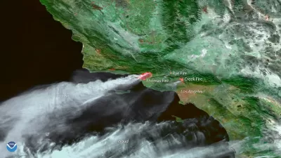
A tweet from the National Oceanic and Atmospheric Administration's @NOAASatellites Twitter handle shared a fascinating but scary model of smoke dispersion from the fires currently burning in Southern California.
NOAA scientists are working on new models using satellite data to project #smoke dispersion, this one shows the projected movement of smoke from the #California #wildfires today. Learn more about satellites: https://t.co/oVYhIsjXNx #ThomasFire #LosAngeles #Ventura pic.twitter.com/l0luTRq0Vo
— NOAA Satellites (@NOAASatellites) December 7, 2017
FULL STORY: Santa Ana Winds Fuel Southern California Wildfires


Friday Eye Candy: Time-Lapse Shows How Rivers Meander
"No man ever steps in the same river twice, for it's not the same river and he's not the same man." -Heraclitus, as quoted by Plato in Cratylus.

Trump Cuts Decimate Mapping Agency
The National Geodetic Survey maintains and updates critical spatial reference systems used extensively in both the public and private sectors.

Rebuilding Smarter: How LA County Is Guiding Fire-Ravaged Communities Toward Resilience
Los Angeles County is leading a coordinated effort to help fire-impacted communities rebuild with resilience by providing recovery resources, promoting fire-wise design, and aligning reconstruction with broader sustainability and climate goals.

Planetizen Federal Action Tracker
A weekly monitor of how Trump’s orders and actions are impacting planners and planning in America.

Map: Where Senate Republicans Want to Sell Your Public Lands
For public land advocates, the Senate Republicans’ proposal to sell millions of acres of public land in the West is “the biggest fight of their careers.”

Restaurant Patios Were a Pandemic Win — Why Were They so Hard to Keep?
Social distancing requirements and changes in travel patterns prompted cities to pilot new uses for street and sidewalk space. Then it got complicated.

Platform Pilsner: Vancouver Transit Agency Releases... a Beer?
TransLink will receive a portion of every sale of the four-pack.

Toronto Weighs Cheaper Transit, Parking Hikes for Major Events
Special event rates would take effect during large festivals, sports games and concerts to ‘discourage driving, manage congestion and free up space for transit.”

Berlin to Consider Car-Free Zone Larger Than Manhattan
The area bound by the 22-mile Ringbahn would still allow 12 uses of a private automobile per year per person, and several other exemptions.
Urban Design for Planners 1: Software Tools
This six-course series explores essential urban design concepts using open source software and equips planners with the tools they need to participate fully in the urban design process.
Planning for Universal Design
Learn the tools for implementing Universal Design in planning regulations.
Heyer Gruel & Associates PA
JM Goldson LLC
Custer County Colorado
City of Camden Redevelopment Agency
City of Astoria
Transportation Research & Education Center (TREC) at Portland State University
Camden Redevelopment Agency
City of Claremont
Municipality of Princeton (NJ)