


The National Geodetic Survey maintains and updates critical spatial reference systems used extensively in both the public and private sectors.
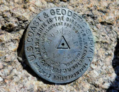
Federal funding and staffing cuts are threatening to have devastating effects on the work of the National Geodetic Survey (NGS), the nation’s oldest scientific agency and one responsible for accurately mapping and measuring the world.
Although little known, the agency’s work is crucial “As the world turns more and more toward operations that need precise coordinate systems like the ones NGS provides,” explains Molly Taft in Wired.
Founded in 1807 by Thomas Jefferson, NGS has expanded its original mapping mission to include “calculating the shape of the Earth, its orientation in space, and its gravitational field.” It is responsible for maintaining the National Spatial Reference System, which informs calculations for crucial infrastructure but has become outdated since its creation in the 1980s. “Ensuring hyper-accurate location is also becoming increasingly important as more and more industries are building up around automation that relies on precise spatial measurements.” The agency was planning to roll out an update of the system to ensure better accuracy.
Now, the agency has lost over a quarter of its staff. “A NOAA budget proposal from the White House Office of Management and Budget sent to the agency in April cuts the budget for the National Ocean Service, which houses NGS, by more than half.”
FULL STORY: Trump Cuts Are Killing a Tiny Office That Keeps Measurements of the World Accurate


New Book Shows How Geographic Technology Tackles Global Challenges
In his new book, Jack Dangermond explores the transformative impact of GIS technology in solving global challenges through spatial data, highlighting its widespread application across sectors and its potential to design sustainable futures.

Building Healthier Communities: The Role of GIS in Park Planning
Integrating Geographic Information Systems (GIS) into park planning enhances community health by promoting physical activity, supporting mental well-being, fostering social connectedness, and addressing public health crises and climate change.
New Book Highlights How GIS Improves Outcomes
Esri Press recently published a digital book called Mapping the Nation which demonstrates how a geographic approach guides important decisions and addresses challenges around the globe.

Maui's Vacation Rental Debate Turns Ugly
Verbal attacks, misinformation campaigns and fistfights plague a high-stakes debate to convert thousands of vacation rentals into long-term housing.

Planetizen Federal Action Tracker
A weekly monitor of how Trump’s orders and actions are impacting planners and planning in America.

San Francisco Suspends Traffic Calming Amidst Record Deaths
Citing “a challenging fiscal landscape,” the city will cease the program on the heels of 42 traffic deaths, including 24 pedestrians.

Adaptive Reuse Will Create Housing in a Suburban Texas Strip Mall
A developer is reimagining a strip mall property as a mixed-use complex with housing and retail.

Study: Anti-Homelessness Laws Don’t Work
Research shows that punitive measures that criminalized unhoused people don’t help reduce homelessness.

In U.S., Urban Gondolas Face Uphill Battle
Cities in Latin America and Europe have embraced aerial transitways — AKA gondolas — as sustainable, convenient urban transport, especially in tricky geographies. American cities have yet to catch up.
Urban Design for Planners 1: Software Tools
This six-course series explores essential urban design concepts using open source software and equips planners with the tools they need to participate fully in the urban design process.
Planning for Universal Design
Learn the tools for implementing Universal Design in planning regulations.
Heyer Gruel & Associates PA
JM Goldson LLC
Custer County Colorado
City of Camden Redevelopment Agency
City of Astoria
Transportation Research & Education Center (TREC) at Portland State University
Jefferson Parish Government
Camden Redevelopment Agency
City of Claremont