


Open data that no one knows how to use is hardly open at all. A new platform from Esri aims to improve the situation.
Laura Bliss reports:
Launched Monday by the global GIS mapping software giant Esri, ArcGIS Hub is an online platform that clusters datasets around specific citywide initiatives, in the hope that people can more readily tap into information applicable to their lives.
According to Bliss, ArcGIS Hub responds to the difficulty in accessing and using data shared on open data portals—although open data has gained wide adoption by governments and agencies of all shapes and sizes, the potential of the platform is still severely limited by poor user experience.
Bliss examines a few case studies for how ArcGIS Hub improves open data, including the example of South Bend, Indiana, one of the early adopters of the platform. Bliss details the functions of the Hub too, which functions in ways like a "social network built on civic duty."
FULL STORY: An Open Data Hub That Builds Better Citizens


Washington DC Launches Open Data Chatbot
City data is now available literally at the public’s fingertips, no data analytics skills required.

New Interactive Mapping Tool Tracks all of NYC's Infrastructure Projects, Housing Permits, and City Facilities
The New York Department of City Planning has taken its open data practices to a new level with the launch of the Capital Planning Explorer.
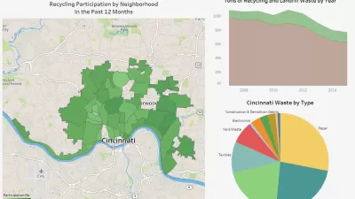
Who Recycles in Cincinnati?
A new CincyInsights dashboard shows recycling participation rates all over the city.

Planetizen Federal Action Tracker
A weekly monitor of how Trump’s orders and actions are impacting planners and planning in America.

Restaurant Patios Were a Pandemic Win — Why Were They so Hard to Keep?
Social distancing requirements and changes in travel patterns prompted cities to pilot new uses for street and sidewalk space. Then it got complicated.

Map: Where Senate Republicans Want to Sell Your Public Lands
For public land advocates, the Senate Republicans’ proposal to sell millions of acres of public land in the West is “the biggest fight of their careers.”

Orange County, Florida Adopts Largest US “Sprawl Repair” Code
The ‘Orange Code’ seeks to rectify decades of sprawl-inducing, car-oriented development.

Maui's Vacation Rental Debate Turns Ugly
Verbal attacks, misinformation campaigns and fistfights plague a high-stakes debate to convert thousands of vacation rentals into long-term housing.

San Francisco Suspends Traffic Calming Amidst Record Deaths
Citing “a challenging fiscal landscape,” the city will cease the program on the heels of 42 traffic deaths, including 24 pedestrians.
Urban Design for Planners 1: Software Tools
This six-course series explores essential urban design concepts using open source software and equips planners with the tools they need to participate fully in the urban design process.
Planning for Universal Design
Learn the tools for implementing Universal Design in planning regulations.
Heyer Gruel & Associates PA
JM Goldson LLC
Custer County Colorado
City of Camden Redevelopment Agency
City of Astoria
Transportation Research & Education Center (TREC) at Portland State University
Camden Redevelopment Agency
City of Claremont
Municipality of Princeton (NJ)