


ESRI

Washington DC Launches Open Data Chatbot
City data is now available literally at the public’s fingertips, no data analytics skills required.

Esri Sets Up COVID-19 GIS Hub
The planning profession can contribute to the worldwide fight to control the spread of COVID-19. GIS technology, for instance, allows real-time monitoring of the pandemic.
Esri App Makes Data Visualization Easy
A wealth of pre-authored policy maps lets users access data to explore public policy issues.

Five Key Data Sources for Park Planning
Park planner Clement Lau discusses five (plus one in Los Angeles) key data sources for parks and recreation planning.

Esri's Jack and Laura Dangermond Make Massive Land Conservation Gift
The Nature Conservancy's largest ever gift will preserve 24,000 acres of highly prized land in California. Jack and Laura Dangermond (cofounders of Esri) made the donation.
A New Tool to Amplify the Power of Open Data
Open data that no one knows how to use is hardly open at all. A new platform from Esri aims to improve the situation.
5 Tips for Analyzing Transit Service
Esri offers insights into five new ways to analyze the success of transit service in cities of all kinds.
The First-Ever 'Ecological Land Units' Map of the World
A new web-based tool by the U.S. Geological Survey (USGS) and Esri allows users to "explore the ecological tapestry of the world."

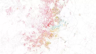
Mapping Lifestyle, Age, Income, and Population Density by ZIP Code
Esri offers a new product called Tapestry Segmentation, which overlays geography with U.S. Census and marketing data.
Mobile App Helps Battle Graffiti in Philadelphia
Philadelphia's Community Life Improvement Program is using Esri's Collector mobile app to empower their data collection in management. Prior to Collector, the anti-graffiti effort was driven by Excel.
Friday Eye Candy: USGS Launches Historical Topographic Map Explorer
A new tool, released in partnership with the U.S. Geological Survey and Esri, provides easy access to historical maps from all over the country, featuring a timeline to easily select maps from different eras.

Crowd-Sourced Infographic Rates Ten Transit Systems
An interactive map featuring a combination of ESRI's Story Maps, Yelp, and TripAdvisor posts shows ten popular subway systems as rated by transit riders.

Build A 3D City Model Within Minutes
ESRI's CityEngine software enables 3D modeling of urban environments. The forthcoming version of the software will enable developers to use the 3D city modeling technology in their own software.
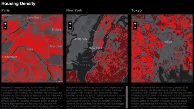
New Tool Facilitates Stunning City Comparisons
The creator of the TED conference has teamed up with Esri to develop an innovative interactive exhibit and online mapping tool to compare 16 global cities along 16 data points, including: population density, open space, and traffic.
Using Geodesign to Model the Complex Intersection of Land Use and Climate Change
The subject of a recent summit hosted by software maker Esri, Larry Greenemeier explains the application of Geodesign to help predict and manage the increasingly complex intersection of design, land use, ecology, and climate change.
Animating San Francisco's Turbulent Decade
A joint project by technology company Esri and the city of San Francisco shows the promising confluence of open data and innovative visualization techniques.
Geocoding the Health Impacts of Your Neighborhood
Ever wonder what effect the pollution you're exposed to in your neighborhood on a daily basis is having on your family's long-term health? The emerging field of geo-medecine is providing answers, reports Christine MacDonald.
Rumor: Microsoft To Buy ESRI?
So if both Microsoft and ESRI are concerned about the Google's move into mapping with the impressive Google Earth, then perhaps a Microsoft-ESRI combination would be the way to fight back. Wow. That's a big rumor.
Urban Design for Planners 1: Software Tools
This six-course series explores essential urban design concepts using open source software and equips planners with the tools they need to participate fully in the urban design process.
Planning for Universal Design
Learn the tools for implementing Universal Design in planning regulations.
Heyer Gruel & Associates PA
JM Goldson LLC
Custer County Colorado
City of Camden Redevelopment Agency
City of Astoria
Transportation Research & Education Center (TREC) at Portland State University
Camden Redevelopment Agency
City of Claremont
Municipality of Princeton (NJ)


