


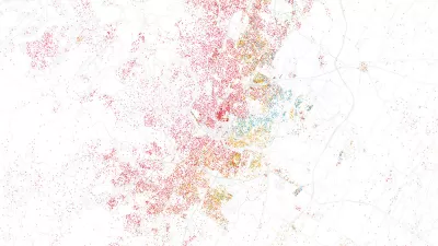
A joint project by technology company Esri and the city of San Francisco shows the promising confluence of open data and innovative visualization techniques.
Ariel Schwartz looks at the successful collaboration that created the San Francisco Urban Revitalization Map,
"a visualization of the city's explosive
growth, and how it has affected different neighborhoods." Created using open data that captures the past 12 years of San Francisco's growth, the animated map shows the city's transformation in vivid colors.
"The map doesn't venture outside San Francisco," says Schwartz, "but there's no reason why
other cities with open data policies can't do similar projects. For
Esri, this is just the beginning--the company is considering doing a
mapathon or maphacking event where data scientists and cartographers get
together to see what they can do with open data. 'We want to show that
web mapping is growing up,' explains [Esri's Jim] Young."
FULL STORY: Visualizing San Francisco’s Urban Growth With Open Data


Washington DC Launches Open Data Chatbot
City data is now available literally at the public’s fingertips, no data analytics skills required.
Esri App Makes Data Visualization Easy
A wealth of pre-authored policy maps lets users access data to explore public policy issues.
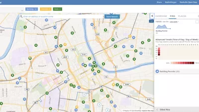
Presenting Municipal Data in an Interactive Map, Nashville Style
The city of Nashville launched the NashView interactive data map earlier this month.

Planetizen Federal Action Tracker
A weekly monitor of how Trump’s orders and actions are impacting planners and planning in America.

Map: Where Senate Republicans Want to Sell Your Public Lands
For public land advocates, the Senate Republicans’ proposal to sell millions of acres of public land in the West is “the biggest fight of their careers.”

Restaurant Patios Were a Pandemic Win — Why Were They so Hard to Keep?
Social distancing requirements and changes in travel patterns prompted cities to pilot new uses for street and sidewalk space. Then it got complicated.

Albuquerque Route 66 Motels Become Affordable Housing
A $4 million city fund is incentivizing developers to breathe new life into derelict midcentury motels.

DC Area County Eliminates Bus Fares
Montgomery County joins a growing trend of making transit free.

Platform Pilsner: Vancouver Transit Agency Releases... a Beer?
TransLink will receive a portion of every sale of the four-pack.
Urban Design for Planners 1: Software Tools
This six-course series explores essential urban design concepts using open source software and equips planners with the tools they need to participate fully in the urban design process.
Planning for Universal Design
Learn the tools for implementing Universal Design in planning regulations.
Heyer Gruel & Associates PA
JM Goldson LLC
Custer County Colorado
City of Camden Redevelopment Agency
City of Astoria
Transportation Research & Education Center (TREC) at Portland State University
Camden Redevelopment Agency
City of Claremont
Municipality of Princeton (NJ)