


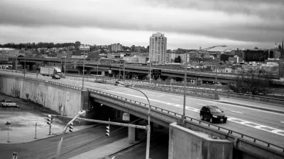
The euphemism refers to a cost-saving measure that's happening even in central districts, to the chagrin of residents. This reversion to gravel roads is one manifestation of a looming local infrastructure deficit.

On some streets in Omaha, Mitch Smith writes, the city is simply unpaving heavily potholed streets in response to a $300 million backlog on road repairs. This follows a long period of repair delays. "For years, an uneasy truce persisted: Public works crews would fill potholes and perform other maintenance work on those roads, but insisted that residents pay if they wanted repaving."
City Hall justifies this stance by stating that many of these suburban roads were low-quality to begin with. "Omaha's policy on unimproved roads is a matter of equity. When the houses were built two generations ago with subpar streets [...] the builder and homeowner saved money."
All of this has residents in an uproar, and some have taken legal action. Reputation is one factor: as central Omaha improves in many ways, unpaving streets looks bad.
Omaha's example is extreme, but similar backpedalling is happening elsewhere too. "In Youngstown, Ohio, officials closed off some uninhabited streets. In Gary, Ind., some of the city's parks could close — a process city officials call 'renaturing' — after years of neglect. And in one Michigan county, a deteriorating bridge was torn down, not replaced."
FULL STORY: Omaha’s Answer to Costly Potholes? Go Back to Gravel Roads

America's Infrastructural Reckoning
Through the lens of Henry Petroski's new book, Tom Vanderbilt discusses why infrastructure, as we have come to define it, is such a fraught topic in American life.
Crack in Bridge Connecting Arkansas to Tennessee Comes With Consequences, Debate
Goods movement on the Mississippi River, as well as truck traffic on a key interstate, has ground to a halt after a crack was discovered last week in a bridge on Interstate 40 connecting to Memphis.
Roads and Bridges Are Not Crumbling
Rebutting the argument that roads and bridges are "crumbling" and should be our first infrastructure priority.

Planetizen Federal Action Tracker
A weekly monitor of how Trump’s orders and actions are impacting planners and planning in America.

Congressman Proposes Bill to Rename DC Metro “Trump Train”
The Make Autorail Great Again Act would withhold federal funding to the system until the Washington Metropolitan Area Transit Authority (WMATA), rebrands as the Washington Metropolitan Authority for Greater Access (WMAGA).

DARTSpace Platform Streamlines Dallas TOD Application Process
The Dallas transit agency hopes a shorter permitting timeline will boost transit-oriented development around rail stations.

San Francisco's School District Spent $105M To Build Affordable Housing for Teachers — And That's Just the Beginning
SFUSD joins a growing list of school districts using their land holdings to address housing affordability challenges faced by their own employees.

Car-Centric LA Suburb Looks to a Train-Oriented Future
City leaders in Rancho Cucamonga, the future western terminus of the Brightline West rail line to Las Vegas, want to reimagine the city as a transit-oriented, pedestrian-friendly community.

New Alaska Bitcoin Mine Would Burn as Much Energy as the State’s Largest Coal Plant
Fueled by “stranded” natural gas, the startup hopes to become the largest in the US, and to make Alaska an industry center.
Urban Design for Planners 1: Software Tools
This six-course series explores essential urban design concepts using open source software and equips planners with the tools they need to participate fully in the urban design process.
Planning for Universal Design
Learn the tools for implementing Universal Design in planning regulations.
Municipality of Princeton
Roanoke Valley-Alleghany Regional Commission
City of Mt Shasta
City of Camden Redevelopment Agency
City of Astoria
Transportation Research & Education Center (TREC) at Portland State University
US High Speed Rail Association
City of Camden Redevelopment Agency
Municipality of Princeton (NJ)