The city of Cleveland's first protected bike path has planning commission approval. The protected path is a component of the city's ambitious bike infrastructure plans.


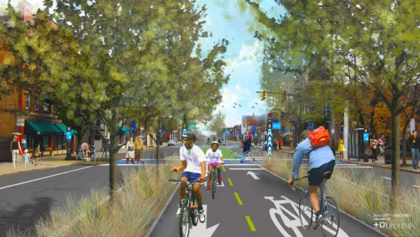
Steven Litt reports that the Cleveland Planning Commission "unanimously approved conceptual plans for the Lorain Avenue Bikeway, modeled after the widely acclaimed Cultural Trail in Indianapolis."
"The $16 million Lorain Avenue project would transform 2.25 miles of the four-lane avenue from West 20th to West 65th Street into a multi-modal route with two lanes for vehicles, a lane for parking and bus stops, and a 10-foot strip separated from traffic for bikes."
If granted final approval, the protected path along Lorain Avenue would further the city's goals of doubling the mileage of city bike paths by 2017. The city also plans to add another 80 miles by 2019, according to Litt. The controversial Opportunity Corridor project also includes plans for a two-mile protected bike path along the route.
Litt notes the argument of complete streets and bike advocates that the city's road infrastructure was built for the larger population of the city in the 20th century, like other cities around the country.
Litt also describes the Cultural Trail in Indianapolis in more detail as an inspiration for the Lorain Avenue Bikeway.
FULL STORY: Lorain Avenue Bikeway concept gets a big boost from Cleveland planning commission (photos)

Two Steps Forward, One Step Back for Cleveland Cycle Track Plans
Advocates are thrilled that the city of Cleveland is seeking federal funding for a pair of ambitious cycle track plans—but one of the plans has been significantly watered down.

Cleveland's First Protected Bike Lanes Get $14 Million Boost
[Updated] The Northeast Ohio Areawide Coordinating Agency will provide the funding for two ambitious protected bike lanes in Cleveland.
Support for a Protected Bike Path Along Cleveland's 'Opportunity Corridor'
The unfolding saga of Cleveland's proposed Opportunity Corridor project has a new twist: community development organizations and bike advocates would like to add a protected bike path alongside the route.

Planetizen Federal Action Tracker
A weekly monitor of how Trump’s orders and actions are impacting planners and planning in America.

The state-sanctioned urbicide of Austin
People don’t kill cities. Freeways do.

US to reduce Colorado River water deliveries to Mexico
A new Colorado Treaty amendment reduces Mexico’s Colorado River water allocation by 250,000 acre feet.

5 New England states march closer to 800 megawatt wind energy project
Securing federal approval for the project may be complicated under the Trump administration, which has historically been hostile towards domestic wind power.

Baltimore to break ground on $50 million Transit Priority Project
The project will bring faster bus trips, safer streets and better bike connections to Baltimore.

Airbnb launches $250 million 'last-dollar financing' housing accelerator, makes first investment in Austin
The company will put $6.4 million towards affordable housing development in Texas’ capital.

FREE Course: Walkable City 1: Why Walkability?
After describing his path towards focusing on walkability as the essence of good planning, Jeff Speck marches through his five principal reasons for making more walkable places.
Reinventing Malls: Planning Alchemy—Turning Gray Fields Into Gold
The course focuses on the opportunities and imperatives that shape reinvention of mall sites.

Eagle County Government
Harvard University Graduate School of Design
Nashville Planning Department
The Architects Foundation
University of Cincinnati Online
The Pocatello Development Authority
The Urban Renewal Agency of the City of Pocatello
Journal of the American Planning Association