


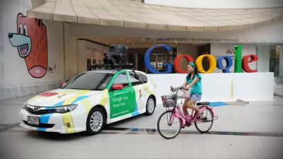
There are intercity Google buses, Google ferries, and now, a Google bike plan to connect neighboring Silicon Valley cities to the growing North Bayshore area of Mountain View. Google is offering $5 million to cities to implement the plan.
"Getting to and from North Bayshore is not exactly pleasant," says Shiloh Ballard, executive director of the Silicon Valley Bicycle Coalition about the "mass of low-slung office parks that surrounds Google’s headquarters and is separated from Mountain View proper by Highway 101," as described last month by Conor Dougherty of The New York Times Bits blog.
"Ballard’s group is one of many that have become concerned about how people can bike from the residential areas of Silicon Valley to North Bayshore, where Google, Microsoft, LinkedIn and dozens of other companies are located," writes Nate Berg for Guardian Cities.
"And, since the city of Mountain View recently made available more than 2.2 million square feet of commercial construction rights in North Bayshore, even more people will be heading to the area in the near future," adds Berg, though most of the development rights did not go to Google but to LinkedIn as we noted last month.
In an effort to improve the bicycle commute to North Bayshore, Google set out to rethink the area’s bicycle infrastructure network. Working with the Silicon Valley Bicycle Coalition, the company commissioned an urban planning consultancy, Alta Planning + Design, to look not only at the area immediately surrounding the Googleplex, but at each of the cities in the general vicinity. The goal was to envision a bike network that would help people get from their homes to the tech offices in North Bayshore, but also for the entire community to have better bike access.
The plan [PDF], written by Christopher Kidd, has high aspirations, devoting a section to "Our Vision: North County-as-Copenhagen" (see page 24), though Berg suggests it "may be more vision than plan."
Google’s vision focuses on expanding the existing bicycle infrastructure in the area and targeting what it calls “high-stress streets” – streets where speed limits are 35 miles per hour or more. By adding strategic infrastructure like protected cycle tracks, multi-use paths and buffered bike lanes, the plan envisions a low-stress bike system that covers 277 miles of roadway in the area, up from 87 miles today.
And perhaps the most important part of the plan is that Google is proposing $5 million "in matching grants to cities or other groups in the region who come up with the best ways to start building this system."
Ballard's group and the Santa Clara Valley Transportation Authority will pick the grant winners, according to Sarah Goodyear of CityLab. She adds that the $5 million is "contingent on the approval of Google’s plans by the Mountain View city council."
FULL STORY: Will Google's $5m plan make cycling in the rest of Silicon Valley easier?


Google Seeks New Direction for Massive Housing Proposal
The company parted ways with its development partner, signaling a shift in strategy for a proposed 15,000-unit housing and office space project on Google-owned land in Silicon Valley.
Google's Plan for the Future of its Campus Would Shift the Expectations for Corporate Campuses
Fast Company details the ambitions of a plan that would add thousands of homes, open space, and commercial development to the home of Google in the Silicon Valley.

Google Tax to Appear on November Ballot in Mountain View, California
If a majority of the city's voters approve the city-sponsored ballot measure, business license fees will change from a flat $30 annual fee to a new tax based on the number of employees, with the largest employer, Google, to pay $3.3 million.

Planetizen Federal Action Tracker
A weekly monitor of how Trump’s orders and actions are impacting planners and planning in America.

Restaurant Patios Were a Pandemic Win — Why Were They so Hard to Keep?
Social distancing requirements and changes in travel patterns prompted cities to pilot new uses for street and sidewalk space. Then it got complicated.

Map: Where Senate Republicans Want to Sell Your Public Lands
For public land advocates, the Senate Republicans’ proposal to sell millions of acres of public land in the West is “the biggest fight of their careers.”

Maui's Vacation Rental Debate Turns Ugly
Verbal attacks, misinformation campaigns and fistfights plague a high-stakes debate to convert thousands of vacation rentals into long-term housing.

San Francisco Suspends Traffic Calming Amidst Record Deaths
Citing “a challenging fiscal landscape,” the city will cease the program on the heels of 42 traffic deaths, including 24 pedestrians.

California Homeless Arrests, Citations Spike After Ruling
An investigation reveals that anti-homeless actions increased up to 500% after Grants Pass v. Johnson — even in cities claiming no policy change.
Urban Design for Planners 1: Software Tools
This six-course series explores essential urban design concepts using open source software and equips planners with the tools they need to participate fully in the urban design process.
Planning for Universal Design
Learn the tools for implementing Universal Design in planning regulations.
Heyer Gruel & Associates PA
JM Goldson LLC
Custer County Colorado
City of Camden Redevelopment Agency
City of Astoria
Transportation Research & Education Center (TREC) at Portland State University
Camden Redevelopment Agency
City of Claremont
Municipality of Princeton (NJ)