


An app that compares fares across transportation network company platforms reveals several lessons about the state of competition in this new transportation frontier.
Brandon G. Donnelly shares news of a survey by whatsthefare that provides "a cost comparison between regular city taxis and ride sharing services such as a UberX, Lyft, and Sidecar in San Francisco, Los Angeles, and New York."
According to Donnelly, the most obvious realization after an initial examination of the data is that "regular taxis are far more expensive in San Francisco and Los Angeles compared to all of the ride sharing services."
The whatsthefare post goes into thorough detail about the comparison at different times of day and different cities, but instead of finding a clear winner in the fare wars, the posts concludes by surmising the "cost of loyalty" to any one of those systems in any of the country's major cities. If you're interested in cutting down on your own cost of loyalty, whatsthefare provides an app that will comparison shop for you before you go.
FULL STORY: Comparing taxis to ride sharing services

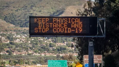
Second Anniversary of the COVID-19 Pandemic
March 11 marked the second anniversary of WHO's declaration of the pandemic and the beginning of its third year. Cases continue to plummet in the U.S. and plateau globally while war in Europe has overshadowed the virus that has killed 6 million.
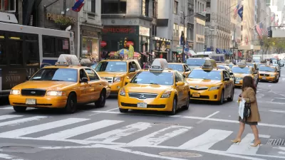
Ride-Hailing Prices Skyrocket as the U.S. Emerges From the Pandemic
A shortage of drivers and spiking demand are driving Uber and Lyft prices higher than ever as the companies struggle to achieve profitability.
2020 Population Growth Rates for the 50 Biggest U.S. Cities
The Census Bureau released new data on May 27 that includes the first four months of the pandemic. Seattle tops the growth rate at 2.2% from July 1, 2019, to July 1, 2020, while Baltimore and San Francisco land at the bottom with -1.4%.

Planetizen Federal Action Tracker
A weekly monitor of how Trump’s orders and actions are impacting planners and planning in America.

Restaurant Patios Were a Pandemic Win — Why Were They so Hard to Keep?
Social distancing requirements and changes in travel patterns prompted cities to pilot new uses for street and sidewalk space. Then it got complicated.

Map: Where Senate Republicans Want to Sell Your Public Lands
For public land advocates, the Senate Republicans’ proposal to sell millions of acres of public land in the West is “the biggest fight of their careers.”

Orange County, Florida Adopts Largest US “Sprawl Repair” Code
The ‘Orange Code’ seeks to rectify decades of sprawl-inducing, car-oriented development.

Maui's Vacation Rental Debate Turns Ugly
Verbal attacks, misinformation campaigns and fistfights plague a high-stakes debate to convert thousands of vacation rentals into long-term housing.

San Francisco Suspends Traffic Calming Amidst Record Deaths
Citing “a challenging fiscal landscape,” the city will cease the program on the heels of 42 traffic deaths, including 24 pedestrians.
Urban Design for Planners 1: Software Tools
This six-course series explores essential urban design concepts using open source software and equips planners with the tools they need to participate fully in the urban design process.
Planning for Universal Design
Learn the tools for implementing Universal Design in planning regulations.
Heyer Gruel & Associates PA
JM Goldson LLC
Custer County Colorado
City of Camden Redevelopment Agency
City of Astoria
Transportation Research & Education Center (TREC) at Portland State University
Camden Redevelopment Agency
City of Claremont
Municipality of Princeton (NJ)