


Google, partnering with the Environmental Defense Fund, has created a series of maps locating methane leaks around three cities in the United States. The question of just how much methane is leaking in a given city comes down to infrastructure.
In three U.S. cities, Boston, Staten Island, and Indianapolis, "Google cars roamed over the past year equipped with sensors to record methane leaks from utility pipes," according to Anya Litvak.
Their purpose: partnering with the Environmental Defense Fund, to map methane leaks. Methane is the second most prevalent greenhouse gas emitted by the human activity of the United States, according to the U.S. Environmental Protection Agency, although it is 21-times as powerful as carbon dioxide at trapping heat in the atmosphere.
"Gas utilities are required to calculate and report their lost gas rate to the state Public Utility Commission annually, but they don’t map the leaks and categorize them by flow rate the way EDF and Google did."
FULL STORY: Google, nonprofit map gas leaks in U.S. cities

Methane Emissions Replace CO2 Emissions— Is This Progress?
For the first time, electricity generated from burning natural gas will surpass coal, largely due to fracking of shale. While that means that carbon dioxide emissions will continue to drop, it also means that methane emissions will increase.
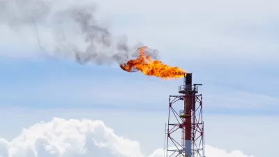
Big Oil Not Happy With Methane Regulation Rollback
The Trump administration's rollback on August 29 of an Obama-era regulation to reduce methane emissions in the production and distribution of oil and natural gas did not sit well with large oil and gas companies who see value in reducing emissions.
Latest Obama-Era Regulations Targeted by the Trump Administration: Methane Rules
One Obama-era climate regulation still on the books deals with methane leakage from oil and gas wells. The greenhouse gas is 25 times more powerful than carbon dioxide. Another methane regulation targeted deals with flaring on federal lands.

Planetizen Federal Action Tracker
A weekly monitor of how Trump’s orders and actions are impacting planners and planning in America.

Map: Where Senate Republicans Want to Sell Your Public Lands
For public land advocates, the Senate Republicans’ proposal to sell millions of acres of public land in the West is “the biggest fight of their careers.”

Restaurant Patios Were a Pandemic Win — Why Were They so Hard to Keep?
Social distancing requirements and changes in travel patterns prompted cities to pilot new uses for street and sidewalk space. Then it got complicated.

Platform Pilsner: Vancouver Transit Agency Releases... a Beer?
TransLink will receive a portion of every sale of the four-pack.

Toronto Weighs Cheaper Transit, Parking Hikes for Major Events
Special event rates would take effect during large festivals, sports games and concerts to ‘discourage driving, manage congestion and free up space for transit.”

Berlin to Consider Car-Free Zone Larger Than Manhattan
The area bound by the 22-mile Ringbahn would still allow 12 uses of a private automobile per year per person, and several other exemptions.
Urban Design for Planners 1: Software Tools
This six-course series explores essential urban design concepts using open source software and equips planners with the tools they need to participate fully in the urban design process.
Planning for Universal Design
Learn the tools for implementing Universal Design in planning regulations.
Heyer Gruel & Associates PA
JM Goldson LLC
Custer County Colorado
City of Camden Redevelopment Agency
City of Astoria
Transportation Research & Education Center (TREC) at Portland State University
Camden Redevelopment Agency
City of Claremont
Municipality of Princeton (NJ)