


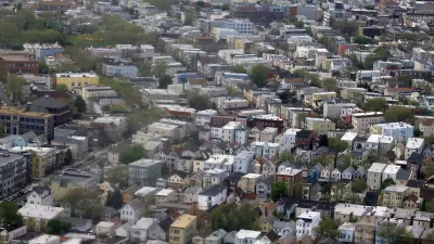
What to do with 200 vacant, industrial acres bordering S.F. Bay in Newark, CA is no easy task for city planners who face activists, including environmentalists, skeptical of any development, let alone one of higher density.
Braden Reddall and Rory Carroll examine the challenges faces the small, East Bay city of Newark as they plan the next phase for the massive, bay-side redevelopment known as the Dumbarton Transit-Oriented Development. The project is located adjacent to a rail station for the proposed Dumbarton commuter railroad crossing of the lower San Francisco Bay, connecting to Redwood City in southern San Mateo county in the West Bay (also known as the Peninsula).
The city is keen on meeting the intent of state law SB 375 - reducing transportation-generated greenhouse gas emissions by a variety of measures, particularly smart growth land use strategies that reduce vehicle trips. "With an eye on the state's new land-use laws to cut carbon output, Newark's city council just voted to convert 200 acres owned largely by chemical companies into a development that should set the trend for a state bent on decarbonising its economy, the world's ninth largest.
The marshes could be turned over to birds, satisfying environmentalists, or paved over with single family homes, like most of the Bay Area. "We're trying to be a post-suburban community," said Terrence Grindall, Newark's community development director. "And then there are the environmentalists and homeowners who do not want the last patches of undeveloped land clogged up with dense housing that's bad for wildlife and property values.
"I wouldn't want to live in something like this. People are going to be packed in like sardines," said Margaret Lewis, a member of the Citizens Committee to Complete the Refuge, a group dedicated to protecting the San Francisco Bay's remaining wetlands, which opposes the Newark project.
According to city plans, "higher densities of residential development-such as condos-would be located within a quarter-mile radius of the transit station, medium densities-such as townhomes-are located slightly further, and single family dwellings are located farthest from the station."
"Having to battle environmentalists for more sustainable projects is not what developers had in mind."
"There's an identity crisis in the environmental movement," said Peter Calthorpe, an urban planner who designed models for the state's regional planners. Environmentalists in the 1970s were the vanguard opposing sprawl. And now, he says, they provide cover for anyone who opposes dense urban housing.
FULL STORY: California planning low-carbon oasis where cars aren't king

Tea Party Sinks Planning Meeting
Public outreach on SB 375, California's climate change bill, began last month in the San Francisco Bay Area. But the East Bay Tea Party had other plans.

Gateway Tunnel Project Ready to Move Forward
The project is primarily funded through federal agencies and will improve a key link between New Jersey and New York City.
Newark Kicks Off $1 Home Sale Program
The city sold seven properties as part of an effort to revive blighted sites and encourage housing production.

Planetizen Federal Action Tracker
A weekly monitor of how Trump’s orders and actions are impacting planners and planning in America.

Map: Where Senate Republicans Want to Sell Your Public Lands
For public land advocates, the Senate Republicans’ proposal to sell millions of acres of public land in the West is “the biggest fight of their careers.”

Restaurant Patios Were a Pandemic Win — Why Were They so Hard to Keep?
Social distancing requirements and changes in travel patterns prompted cities to pilot new uses for street and sidewalk space. Then it got complicated.

Platform Pilsner: Vancouver Transit Agency Releases... a Beer?
TransLink will receive a portion of every sale of the four-pack.

Toronto Weighs Cheaper Transit, Parking Hikes for Major Events
Special event rates would take effect during large festivals, sports games and concerts to ‘discourage driving, manage congestion and free up space for transit.”

Berlin to Consider Car-Free Zone Larger Than Manhattan
The area bound by the 22-mile Ringbahn would still allow 12 uses of a private automobile per year per person, and several other exemptions.
Urban Design for Planners 1: Software Tools
This six-course series explores essential urban design concepts using open source software and equips planners with the tools they need to participate fully in the urban design process.
Planning for Universal Design
Learn the tools for implementing Universal Design in planning regulations.
Heyer Gruel & Associates PA
JM Goldson LLC
Custer County Colorado
City of Camden Redevelopment Agency
City of Astoria
Transportation Research & Education Center (TREC) at Portland State University
Camden Redevelopment Agency
City of Claremont
Municipality of Princeton (NJ)