


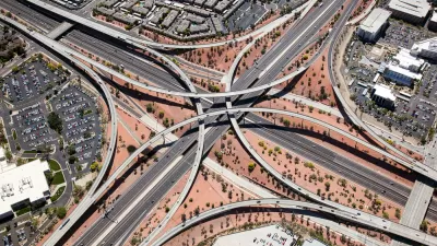
The State of New Hampshire has created an interactive online tool for its municipalities to examine the impacts of different land use scenarios, in the hopes of promoting smart growth. Geneva Faulkner describes how it works.
Created by RKG Associates, Placeways, and Urban Interactive Studio, under the auspices of the New Hampshire Office of Energy and Planning (NHOEP), the New Hampshire Cost of Sprawl Impact Model was developed to assist the state's planners, elected officials, and interested community members in understanding the fiscal impacts of land use decisions.
Users are able to analyze different types and scales of development for specific parcels in one of the state's 239 municipalities. Based on those selections, the tool produces information on expected "population and housing impact,
municipal fiscal cost, the percentages of land developed, and the
infrastructure needed for that particular scenario," writes Faulkner.
"Instead of having to perform calculations to determine floor area
ratios, the additional miles of road that would need to be built,
population growth and infrastructure, as well as other time-consuming
models, the Cost of Sprawl tool performs complex calculations
instantaneously, therefore allowing planners to spend less time
analyzing one particular scenario and more time understanding the
impacts of a variety of scenarios."
FULL STORY: Online Tool Helps New Hampshire Municipalities Examine the Cost of Sprawl

The Economic Defense of Sprawl (And What's Wrong With It)
Defenders of suburban expansion argue that government should build more roads in order to open up more land for housing. What's wrong with that argument?
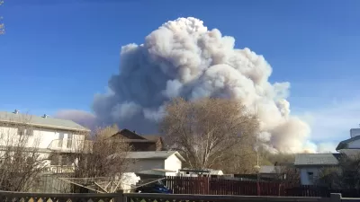
What Goes Together? Sprawl and Destructive Wildfires
Wildfires tend to start at the Wildland-Urban Interface: those border zones between cities and the open land surrounding them. Keeping the lid on sprawl, it can be argued, would tame the inferno.
American Suburbia Transplanted to Beijing
Chinese and Indian cities have been quick to welcome housing developments modeled on North American suburbs, including "Orange County" and "Vancouver Forest" in Beijing. This globalized sprawl perpetuates all the ills of our own.

Planetizen Federal Action Tracker
A weekly monitor of how Trump’s orders and actions are impacting planners and planning in America.

Map: Where Senate Republicans Want to Sell Your Public Lands
For public land advocates, the Senate Republicans’ proposal to sell millions of acres of public land in the West is “the biggest fight of their careers.”

Restaurant Patios Were a Pandemic Win — Why Were They so Hard to Keep?
Social distancing requirements and changes in travel patterns prompted cities to pilot new uses for street and sidewalk space. Then it got complicated.

Platform Pilsner: Vancouver Transit Agency Releases... a Beer?
TransLink will receive a portion of every sale of the four-pack.

Toronto Weighs Cheaper Transit, Parking Hikes for Major Events
Special event rates would take effect during large festivals, sports games and concerts to ‘discourage driving, manage congestion and free up space for transit.”

Berlin to Consider Car-Free Zone Larger Than Manhattan
The area bound by the 22-mile Ringbahn would still allow 12 uses of a private automobile per year per person, and several other exemptions.
Urban Design for Planners 1: Software Tools
This six-course series explores essential urban design concepts using open source software and equips planners with the tools they need to participate fully in the urban design process.
Planning for Universal Design
Learn the tools for implementing Universal Design in planning regulations.
Heyer Gruel & Associates PA
JM Goldson LLC
Custer County Colorado
City of Camden Redevelopment Agency
City of Astoria
Transportation Research & Education Center (TREC) at Portland State University
Camden Redevelopment Agency
City of Claremont
Municipality of Princeton (NJ)