


Certain parts of the city generate "buzz" -- through events, parties, or other attractions. Just how much buzz they create is hard to nail down. But a new study focusing on L.A. and New York seeks to quantify the cool factor that makes places pop.
"The research, presented in late March at the annual meeting of the Association of American Geographers, locates hot spots based on the frequency and draw of cultural happenings: film and television screenings, concerts, fashion shows, gallery and theater openings. The buzziest areas in New York, it finds, are around Lincoln and Rockefeller Centers, and down Broadway from Times Square into SoHo. In Los Angeles the cool stuff happens in Beverly Hills and Hollywood, along the Sunset Strip, not in trendy Silver Lake or Echo Park."
"The aim of the study, called 'The Geography of Buzz,' said Elizabeth Currid, one of its authors, was 'to be able to quantify and understand, visually and spatially, how this creative cultural scene really worked.'"
"To find out, Ms. Currid, an assistant professor in the School of Policy, Planning and Development at the University of Southern California in Los Angeles, and her co-author, Sarah Williams, the director of the Spatial Information Design Lab at Columbia University's Graduate School of Architecture, Planning and Preservation, mined thousands of photographs from Getty Images that chronicled flashy parties and smaller affairs on both coasts for a year, beginning in March 2006. It was not a culturally comprehensive data set, the researchers admit, but a wide-ranging one. And because the photos were for sale, they had to be of events that people found inherently interesting, 'a good proxy for ‘buzz-worthy' social contexts,' they write. You had to be there, but where exactly was there? And why was it there?"
FULL STORY: Mapping the Cultural Buzz: How Cool Is That?


Flood Resilience Through Green Infrastructure
Cities like New York and Los Angeles are moving to build green infrastructure as the need for spongier urban spaces becomes more apparent.
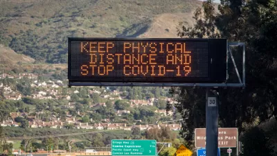
Second Anniversary of the COVID-19 Pandemic
March 11 marked the second anniversary of WHO's declaration of the pandemic and the beginning of its third year. Cases continue to plummet in the U.S. and plateau globally while war in Europe has overshadowed the virus that has killed 6 million.
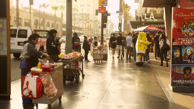
Legalizing Street Vending: Lessons from Los Angeles
With new regulations poised to add 400 new vendors to New York City's streets every year for the next decade, city leaders can look to L.A.'s recent legalization efforts for guidance.

Planetizen Federal Action Tracker
A weekly monitor of how Trump’s orders and actions are impacting planners and planning in America.

Map: Where Senate Republicans Want to Sell Your Public Lands
For public land advocates, the Senate Republicans’ proposal to sell millions of acres of public land in the West is “the biggest fight of their careers.”

Restaurant Patios Were a Pandemic Win — Why Were They so Hard to Keep?
Social distancing requirements and changes in travel patterns prompted cities to pilot new uses for street and sidewalk space. Then it got complicated.

Platform Pilsner: Vancouver Transit Agency Releases... a Beer?
TransLink will receive a portion of every sale of the four-pack.

Toronto Weighs Cheaper Transit, Parking Hikes for Major Events
Special event rates would take effect during large festivals, sports games and concerts to ‘discourage driving, manage congestion and free up space for transit.”

Berlin to Consider Car-Free Zone Larger Than Manhattan
The area bound by the 22-mile Ringbahn would still allow 12 uses of a private automobile per year per person, and several other exemptions.
Urban Design for Planners 1: Software Tools
This six-course series explores essential urban design concepts using open source software and equips planners with the tools they need to participate fully in the urban design process.
Planning for Universal Design
Learn the tools for implementing Universal Design in planning regulations.
Heyer Gruel & Associates PA
JM Goldson LLC
Custer County Colorado
City of Camden Redevelopment Agency
City of Astoria
Transportation Research & Education Center (TREC) at Portland State University
Camden Redevelopment Agency
City of Claremont
Municipality of Princeton (NJ)