


SDOT has installed safety improvements at more than 260 public schools since 2015.
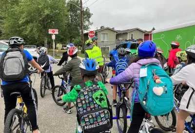
The Seattle Department of Transportation (SDOT) announced it has met its goal to make safety improvements to intersections around all public schools in the city.
The goal was established by the 2015 Move Seattle Levy. According to a press release from the Mayor’s office, “Since the Levy’s approval in 2015, SDOT has built over 260 school-focused projects citywide. Safe Routes to School projects often include upgrades to sidewalks, crosswalks, speed cushions, and other kinds of traffic calming.” The city’s 2023-2024 Safe Routes to School Annual Report notes that 28 percent of Seattle students walk or bike to school, and that adding speed cushions has led to a 21 percent reduction in speeds on arterial streets.
SDOT also offers community initiatives that include giving out essential safety items for community and school groups. “Additionally, schools, PTAs, and community groups can apply for grants of up to $1,000 to organize walking and biking activities, such as walking/biking school buses.” Another program, School Streets, has closed off 16 street segments to traffic during school hours to make walking and biking to school safer for children and families.

Safe Streets Grants: What to Know
This year’s round of Safe Streets for All grant criteria come with some changes.
Indy Neighborhood Group Builds Temporary Multi-Use Path
Community members, aided in part by funding from the city, repurposed a vehicle lane to create a protected bike and pedestrian path for the summer season.
Safe Streets Funding in Jeopardy
The Trump administration is specifically targeting bike infrastructure and other road safety projects in its funding cuts.

Planetizen Federal Action Tracker
A weekly monitor of how Trump’s orders and actions are impacting planners and planning in America.

Congressman Proposes Bill to Rename DC Metro “Trump Train”
The Make Autorail Great Again Act would withhold federal funding to the system until the Washington Metropolitan Area Transit Authority (WMATA), rebrands as the Washington Metropolitan Authority for Greater Access (WMAGA).

The Simple Legislative Tool Transforming Vacant Downtowns
In California, Michigan and Georgia, an easy win is bringing dollars — and delight — back to city centers.

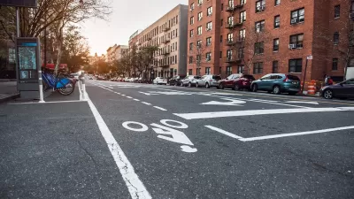
Supporting Cycling Takes More Than Just Bike Lanes
Safe, protected bike lanes are a key part of a city’s bike infrastructure — but secure parking, e-bike charging, and other amenities can also influence people’s shift to cycling.

Judge Blocks Anti-DEI Rules for Transportation, Housing Grants
A second injunction blocks the Trump administration from enforcing new regulations for federal funding.

Unhoused People in San Jose Could Face Arrest if They Refuse Shelter
A policy proposed by the city’s mayor would give law enforcement the option to arrest homeless residents if they refuse three offers of housing.
Urban Design for Planners 1: Software Tools
This six-course series explores essential urban design concepts using open source software and equips planners with the tools they need to participate fully in the urban design process.
Planning for Universal Design
Learn the tools for implementing Universal Design in planning regulations.
Smith Gee Studio
City of Charlotte
City of Camden Redevelopment Agency
City of Astoria
Transportation Research & Education Center (TREC) at Portland State University
US High Speed Rail Association
City of Camden Redevelopment Agency
Municipality of Princeton (NJ)