


After three months of study and analysis, NACTO is providing authoritative guidance on new ways of thinking about rights of way now that the coronavirus has changed the way we live and work in cities.
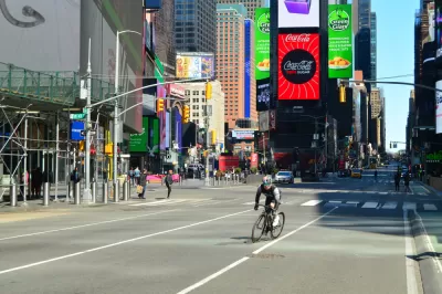
The National Association of City Transportation Officials (NACTO) released a new guide to street design for the ongoing pandemic and the future recovery.
The "Streets for Pandemic Response and Recovery" report showcases specific design and management tools "to keep essential workers and goods moving, provide safe access to grocery stores and other essential businesses, and ensure that people have safe space for social/physical distancing while getting outside," according to NACTO.
The report includes descriptions of emerging practices from around the world as well as implementation resources for communities. The following street features are addressed specifically in the report:
- Lanes for Biking & Rolling
- Sidewalk Extensions
- Transit Lanes
- Slow Streets
- Pick-Up & Delivery Zones
- Outdoor Dining
- Markets
An article by Kea Wilson provides additional background on how NACTO created the report, and shares insights into a few of the larger themes present in the report, liking designing for equity, the need for flexibility in design response, the post-pandemic sidewalk, and the need to balance outdoor restaurant space with space for pedestrians. Wilson wrote a separate article to address that last point more specifically, and in greater detail.
FULL STORY: Streets for Pandemic Response and Recovery

How Oakland Is Fixing its Pandemic Planning Equity Problem
The Oakland Slow Streets program, one of the most controversial developments of the early pandemic, has evolved to become the Essential Places initiative, thanks to new planning practices and a commitment to equity in Oakland, California.

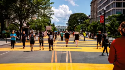
Pandemic Planning Must Reconcile With the Inequities of the Past
The ongoing debate about the role of marginalized communities in the emergency planning programs of the pandemic has now been detailed on the pages of the New York Times.
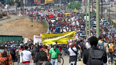
How Emergency Street Redesign Projects Fell Short of the Black Lives Matter Cause
A leading advocate for a new, equity centering approach explains how plans to redesign streets for the needs of the coronavirus pandemic left behind racial justice as a secondary concern.

Planetizen Federal Action Tracker
A weekly monitor of how Trump’s orders and actions are impacting planners and planning in America.

San Francisco's School District Spent $105M To Build Affordable Housing for Teachers — And That's Just the Beginning
SFUSD joins a growing list of school districts using their land holdings to address housing affordability challenges faced by their own employees.

The Tiny, Adorable $7,000 Car Turning Japan Onto EVs
The single seat Mibot charges from a regular plug as quickly as an iPad, and is about half the price of an average EV.

Seattle's Plan for Adopting Driverless Cars
Equity, safety, accessibility and affordability are front of mind as the city prepares for robotaxis and other autonomous vehicles.

As Trump Phases Out FEMA, Is It Time to Flee the Floodplains?
With less federal funding available for disaster relief efforts, the need to relocate at-risk communities is more urgent than ever.

With Protected Lanes, 460% More People Commute by Bike
For those needing more ammo, more data proving what we already knew is here.
Urban Design for Planners 1: Software Tools
This six-course series explores essential urban design concepts using open source software and equips planners with the tools they need to participate fully in the urban design process.
Planning for Universal Design
Learn the tools for implementing Universal Design in planning regulations.
Smith Gee Studio
City of Charlotte
City of Camden Redevelopment Agency
City of Astoria
Transportation Research & Education Center (TREC) at Portland State University
US High Speed Rail Association
City of Camden Redevelopment Agency
Municipality of Princeton (NJ)