


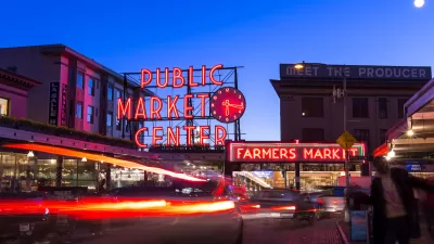
After decades of debate, the market is testing a car ban in one of its busiest areas and adding walking links to the surrounding neighborhood.
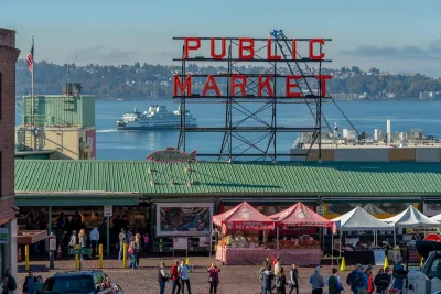
Seattle’s Pike Place Market is limiting the types of vehicles that can drive through the market area in an effort to make the historic market more walkable and safe for visitors and spur more economic activity, reports Nate Sanford for Cascade PBS.
According to Sanford, “Prior to the car ban, it was common to see tourists in vehicles inching through the crowds, seemingly confused and in a situation they hadn’t intended.” The new car ban applies to the first main block between Pike and Pine Streets and is currently designed to be temporary. “Vehicles needed for vendor deliveries, emergencies and some customer pickups are still allowed, as are cars with disability parking permits.” Visitors can access the market via the new Waterfront Park and Overlook Walk Skybridge.
The change is part of a broader effort to revitalize the neighborhood and reengage with local residents. “After making their way through the newly pedestrianized Market, visitors can make their way downtown through a revitalized pedestrian-only plaza on First and Pike, which opened last month with new furniture, planters and daily programming.” Through the summer, the Pike Place Market Preservation and Development Authority plans to add more outdoor seating and events to draw locals.
FULL STORY: ‘Vastly more walkable’: Seattle’s Pike Place Market tests car ban

Pike Place Market Vendors Open to Pedestrianization
A survey of local business owners and vendors upends the common belief that frontline workers don’t support restricting vehicle access to the iconic Seattle market.
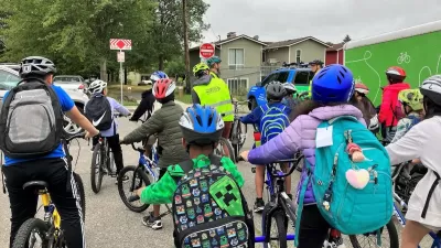
How Seattle Achieved Safe Routes to School Goal
SDOT has installed safety improvements at more than 260 public schools since 2015.
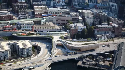
Seattle’s New Overlook Walk Offers Ample Park Space Near Pike Place Market
The elevated park and event space replaces part of the demolished Alaskan Way Viaduct, connecting the city’s famous Pike Place Market to the waterfront.

Planetizen Federal Action Tracker
A weekly monitor of how Trump’s orders and actions are impacting planners and planning in America.

Map: Where Senate Republicans Want to Sell Your Public Lands
For public land advocates, the Senate Republicans’ proposal to sell millions of acres of public land in the West is “the biggest fight of their careers.”

Restaurant Patios Were a Pandemic Win — Why Were They so Hard to Keep?
Social distancing requirements and changes in travel patterns prompted cities to pilot new uses for street and sidewalk space. Then it got complicated.

Platform Pilsner: Vancouver Transit Agency Releases... a Beer?
TransLink will receive a portion of every sale of the four-pack.

Toronto Weighs Cheaper Transit, Parking Hikes for Major Events
Special event rates would take effect during large festivals, sports games and concerts to ‘discourage driving, manage congestion and free up space for transit.”

Berlin to Consider Car-Free Zone Larger Than Manhattan
The area bound by the 22-mile Ringbahn would still allow 12 uses of a private automobile per year per person, and several other exemptions.
Urban Design for Planners 1: Software Tools
This six-course series explores essential urban design concepts using open source software and equips planners with the tools they need to participate fully in the urban design process.
Planning for Universal Design
Learn the tools for implementing Universal Design in planning regulations.
Heyer Gruel & Associates PA
JM Goldson LLC
Custer County Colorado
City of Camden Redevelopment Agency
City of Astoria
Transportation Research & Education Center (TREC) at Portland State University
Camden Redevelopment Agency
City of Claremont
Municipality of Princeton (NJ)