


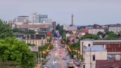
State and local officials are zeroing in on some of the region’s most dangerous streets and transit corridors.

Safety improvements are coming to a major street in Oakland, California, reports Kristin J. Bender in The Mercury News, after 18 or more pedestrians were killed on International Boulevard in the last two years. “Improvements are being funded by a $400,000 grant from the Metropolitan Transportation Commission and $1.8 million from the city of Oakland, officials said.”
The project joins other efforts to make Bay Area streets safer and more connected for pedestrians, transit users, and cyclists. In San Mateo County, the local transportation authority plans to improve sidewalk crossings and bike and pedestrian routes that connect to Caltrain, BART, and other public transit. “That could include building pathways over or under the elevated Caltrain tracks and adjacent Highway 101 corridor to better connect the downtown area to the city’s job center and biotech hub in its former industrial core to the east.”
Bender notes that “last week, the Regional Network Management Council, a coalition of Bay Area transit agencies, earmarked more than $18 million for eight projects under the Bus Accelerated Infrastructure Delivery program, commonly known as ‘BusAID.’” The program is designed to improve bus speed and reliability and make key transit corridors safer for all users.
FULL STORY: Deadly Bay Area streets spark officials to make traffic safety improvements


Jacksonville Takes Action on Vision Zero
The city is implementing its first-ever Vision Zero Action Plan in an effort to reduce pedestrian and cyclist deaths and serious injuries.
Milwaukee Launches Vision Zero Plan
Seven years after the city signed its Complete Streets Policy, the city is doubling down on its efforts to eliminate traffic deaths.

‘Complete Streets’ Webpage Deleted in Federal Purge
Basic resources and information on building bike lanes and sidewalks, formerly housed on the government’s Complete Streets website, are now gone.

Maui's Vacation Rental Debate Turns Ugly
Verbal attacks, misinformation campaigns and fistfights plague a high-stakes debate to convert thousands of vacation rentals into long-term housing.

Planetizen Federal Action Tracker
A weekly monitor of how Trump’s orders and actions are impacting planners and planning in America.

In Urban Planning, AI Prompting Could be the New Design Thinking
Creativity has long been key to great urban design. What if we see AI as our new creative partner?

Pedestrian Deaths Drop, Remain Twice as High as in 2009
Fatalities declined by 4 percent in 2024, but the U.S. is still nowhere close to ‘Vision Zero.’

King County Supportive Housing Program Offers Hope for Unhoused Residents
The county is taking a ‘Housing First’ approach that prioritizes getting people into housing, then offering wraparound supportive services.

Researchers Use AI to Get Clearer Picture of US Housing
Analysts are using artificial intelligence to supercharge their research by allowing them to comb through data faster. Though these AI tools can be error prone, they save time and housing researchers are optimistic about the future.
Urban Design for Planners 1: Software Tools
This six-course series explores essential urban design concepts using open source software and equips planners with the tools they need to participate fully in the urban design process.
Planning for Universal Design
Learn the tools for implementing Universal Design in planning regulations.
planning NEXT
Appalachian Highlands Housing Partners
Mpact (founded as Rail~Volution)
City of Camden Redevelopment Agency
City of Astoria
City of Portland
City of Laramie