


The Bay Area Council and CBRE created an economic tracker to measure how well the nation's 25 largest metropolitan areas have recovered from the public health restrictions imposed on their regions at the onset of the pandemic.

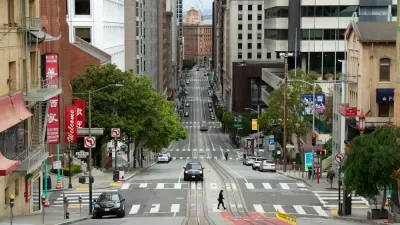
“San Francisco’s recovery from the throes of the COVID-19 pandemic is one of the worst in the country among major metropolitan areas, according to an economic recovery tracker launched Tuesday by the Bay Area Council business group,” reports Eli Walsh of the Bay City News Foundation on Feb. 28.
That would be the San Francisco metropolitan statistical area, not the city. From a related, pandemic post:
Metros, or Metropolitan Statistical Areas (MSAs), are census-defined regions that consist of a city with 50,000 or more inhabitants and its surrounding communities.
The San Francisco–Oakland–Berkeley metro consists of five counties: Marin, San Francisco, San Mateo, Alameda and Contra Costa.
“Among the 25 largest metro areas in the country by regional gross domestic product, San Francisco’s pandemic recovery ranked 24th on the Regional Economic Recovery Index, besting only Baltimore,” adds Walsh.
San Jose fared better, but is still in the back half of the ranking at 16th. The Austin, Dallas and Denver metro areas have had the greatest recovery to date, according to the Bay Area Council.
The initial report by the council's Economic Institute, prepared in partnership with the commercial real estate services company CBRE and its Tech Insights Center, is the first of a three-year, three-part series of interactive reports focused on the Bay Area's economic recovery.
"The index portion of the project is focused on the 5 county San Francisco MSA (plus 2 county San Jose MSA)," wrote Abby Raisz of the Bay Area Council in an email on March 2. “The 'Bay Area Deep Dive' section includes charts that encompass the entire 9 county Bay Area.”
The region was the first in the nation to issue a "shelter in place order” on March 16, 2020, and appears almost last to recover from shutting down all but essential services in order to stem the transmission of the coronavirus that causes COVID-19.
“As the region recovers, it is clear that the pandemic has permanently changed how and where people work, how businesses think about their location decisions, and where households choose to live," notes the project summary of the report. “These effects appear to be most visible in expensive coastal regions, including the San Francisco Bay Area.”
Austin, Texas ranked first across the 25 regions in the study, scoring an average of 86 (out of 100) across the 15 metrics evaluated, according to the report's index methodology:
Within these metrics, it ranked first (100/100) on 6 metrics: job growth, “knowledge worker” growth, population growth, labor force growth, net absorption, and new housing units per capita. It also scored high (second only to Denver) on change in sales tax revenue – experiencing an increase of $33 million (or 13%) from 2019 to 2021.
These figures speak to the dramatic resilience and growth Austin, and Texas as a whole, experienced during the pandemic, while coastal cities like San Francisco and New York continue to suffer losses.
Related post detailing the population loss in the Bay Area: State Estimates Show Third Year of Population Loss for California, February 5, 2023,
Hat tip to my local paper, the San Mateo Daily Journal.
FULL STORY: SF pandemic recovery one of the worst in U.S. among largest metro areas


2020 Population Growth Rates for the 50 Biggest U.S. Cities
The Census Bureau released new data on May 27 that includes the first four months of the pandemic. Seattle tops the growth rate at 2.2% from July 1, 2019, to July 1, 2020, while Baltimore and San Francisco land at the bottom with -1.4%.

Pandemic-Era Economic Growth in Metropolitan Areas
The world has gone through three turbulent years of Covid-19. The Brookings Institution continues its analysis of inclusive economic growth in 192 metropolitan areas in the U.S. during this period with the publication of Metro Monitor 2023.
Contrasting the Coronavirus Impact in the Bay Area to New York City
Early intervention, or population density? NPR reporters based in the Bay Area and New York City offer explanations as to why the two regions are seeing such a wide contrast in experiences during the coronavirus outbreak.

Planetizen Federal Action Tracker
A weekly monitor of how Trump’s orders and actions are impacting planners and planning in America.

Chicago’s Ghost Rails
Just beneath the surface of the modern city lie the remnants of its expansive early 20th-century streetcar system.

San Antonio and Austin are Fusing Into one Massive Megaregion
The region spanning the two central Texas cities is growing fast, posing challenges for local infrastructure and water supplies.

Since Zion's Shuttles Went Electric “The Smog is Gone”
Visitors to Zion National Park can enjoy the canyon via the nation’s first fully electric park shuttle system.

Trump Distributing DOT Safety Funds at 1/10 Rate of Biden
Funds for Safe Streets and other transportation safety and equity programs are being held up by administrative reviews and conflicts with the Trump administration’s priorities.

German Cities Subsidize Taxis for Women Amid Wave of Violence
Free or low-cost taxi rides can help women navigate cities more safely, but critics say the programs don't address the root causes of violence against women.
Urban Design for Planners 1: Software Tools
This six-course series explores essential urban design concepts using open source software and equips planners with the tools they need to participate fully in the urban design process.
Planning for Universal Design
Learn the tools for implementing Universal Design in planning regulations.
planning NEXT
Appalachian Highlands Housing Partners
Mpact (founded as Rail~Volution)
City of Camden Redevelopment Agency
City of Astoria
City of Portland
City of Laramie