


New York City Mayor Eric Adams has the federal funding to launch a new, equity-focused bike and pedestrian planning initiative.
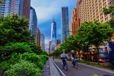
“Mayor Eric Adams is targeting areas with a lack of good transportation and jobs for an expansion of the city’s greenway network, using $7.25 million in federal infrastructure funding to plan for the new bike paths,” reports Kevin Duggan.
The funding comes from the U.S. Department of Transportation’s RAISE grant program, announced in August.
““This funding will help New York City build out our world-class greenway network to support the booming cycling ridership we’ve seen during the pandemic,” said New York City Department of Transportation (NYCDOT) Commissioner Ydanis Rodriguez in a press release from Mayor Eric Adams’s office.
NYCDOT, NYC Parks, and the New York Economic Development Corporation will work together to create a comprehensive greenway vision plan, the city’s first in 30 years, to guide future projects and measure the growth and other trends related to biking in the city. The plan will first identify five corridors for pedestrian and bike infrastructure upgrades, prioritizing low and moderate-income areas outside of Manhattan.
“Potential new greenway sections include an extension of Brooklyn’s Eastern Parkway into Brownsville, the Jamaica Bay Greenway into southeast Queens, along the Harlem River in the Bronx, and Staten Island’s North Shore, according to a map the city submitted to the feds,” reports Duggan.
FULL STORY: NYC uses $7M federal grant to plan more greenways in underserved communities

NYC DOT Podcast Makes Transportation Planning Accessible
‘Curb Enthusiasm’ features transportation experts and discussions on local, national, and global transportation planning topics.

NYC Open Streets Program Faces Lawsuit
A group of residents is charging the city with violating accessibility requirements by blocking vehicular traffic on some blocks.
New York DOT Status Report Shows Slow Progress on Bus, Bike Lanes
According to a report released by the agency, NYCDOT failed to meet its benchmarks for installing new dedicated bus and bike lanes.

Planetizen Federal Action Tracker
A weekly monitor of how Trump’s orders and actions are impacting planners and planning in America.

Restaurant Patios Were a Pandemic Win — Why Were They so Hard to Keep?
Social distancing requirements and changes in travel patterns prompted cities to pilot new uses for street and sidewalk space. Then it got complicated.

Map: Where Senate Republicans Want to Sell Your Public Lands
For public land advocates, the Senate Republicans’ proposal to sell millions of acres of public land in the West is “the biggest fight of their careers.”

Maui's Vacation Rental Debate Turns Ugly
Verbal attacks, misinformation campaigns and fistfights plague a high-stakes debate to convert thousands of vacation rentals into long-term housing.

San Francisco Suspends Traffic Calming Amidst Record Deaths
Citing “a challenging fiscal landscape,” the city will cease the program on the heels of 42 traffic deaths, including 24 pedestrians.

California Homeless Arrests, Citations Spike After Ruling
An investigation reveals that anti-homeless actions increased up to 500% after Grants Pass v. Johnson — even in cities claiming no policy change.
Urban Design for Planners 1: Software Tools
This six-course series explores essential urban design concepts using open source software and equips planners with the tools they need to participate fully in the urban design process.
Planning for Universal Design
Learn the tools for implementing Universal Design in planning regulations.
Heyer Gruel & Associates PA
JM Goldson LLC
Custer County Colorado
City of Camden Redevelopment Agency
City of Astoria
Transportation Research & Education Center (TREC) at Portland State University
Camden Redevelopment Agency
City of Claremont
Municipality of Princeton (NJ)