


The road markings known as 'sharrows' are meant to make streets safer for cyclists, but critics argue they're nothing but a convenient compromise that favors drivers and fails to improve road safety.

In a post on Medium, Peter Flax argues that sharrows––the painted road markers indicating a lane shared by cars and bicycles formally known as Shared Lane Markings (SLMs)––are "the bane of American roads: confusing, useless––worse than useless, actually––and deployed in bad faith."
While sharrows may sound "okay on paper," writes Flax, the vague signage designed to remind drivers that cyclists can use the full lane does little to improve bicyclist safety. According to Flax, "some drivers get doubly confused by the presence of sharrows, and conclude erroneously that bike riders only have the right to take the lane where this signage and marking exist." He points to a 2018 study that concludes that sharrows may provide bike riders with a "false sense of security," leading to more crashes and injuries, and often pose more danger to cyclists than not having any bike markings at all.
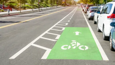
Flax goes on to claim that, in many cases, sharrows serve as a convenient way for politicians to pay lip service to bike activists without making significant improvements or spending very much money, "deployed as a bad-faith alternative to actually making roads safer for bike riders." Other critics agree, while research consistently shows that protected or buffered bike lanes are the best way to protect bicyclists and encourage more people to integrate bikes into their daily lives.
FULL STORY: Why Sharrows Are Bullshit

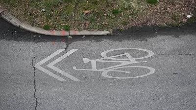
Sharrows Are Ineffective, Potentially Counterproductive
Research shows there’s no substitute for protected bike lanes, and sharrows may make roads more dangerous for cyclists.
Why Bike Lanes Are Good: An Explainer for the US Transportation Secretary
Sean Duffy says there’s no evidence that bike lanes have benefits. Streetsblog — and federal agencies’ own data — beg to differ.
Houston Mayor Promises Dedicated Austin Street Bike Lane After Public Backlash
Although the one-way bike lane won’t be protected by physical barriers, the proposal is an improvement over the mayor’s initial plan to only include sharrows on the Austin Street project.

Planetizen Federal Action Tracker
A weekly monitor of how Trump’s orders and actions are impacting planners and planning in America.

Maui's Vacation Rental Debate Turns Ugly
Verbal attacks, misinformation campaigns and fistfights plague a high-stakes debate to convert thousands of vacation rentals into long-term housing.

Restaurant Patios Were a Pandemic Win — Why Were They so Hard to Keep?
Social distancing requirements and changes in travel patterns prompted cities to pilot new uses for street and sidewalk space. Then it got complicated.

In California Battle of Housing vs. Environment, Housing Just Won
A new state law significantly limits the power of CEQA, an environmental review law that served as a powerful tool for blocking new development.

Boulder Eliminates Parking Minimums Citywide
Officials estimate the cost of building a single underground parking space at up to $100,000.

Orange County, Florida Adopts Largest US “Sprawl Repair” Code
The ‘Orange Code’ seeks to rectify decades of sprawl-inducing, car-oriented development.
Urban Design for Planners 1: Software Tools
This six-course series explores essential urban design concepts using open source software and equips planners with the tools they need to participate fully in the urban design process.
Planning for Universal Design
Learn the tools for implementing Universal Design in planning regulations.
Heyer Gruel & Associates PA
JM Goldson LLC
Custer County Colorado
City of Camden Redevelopment Agency
City of Astoria
Transportation Research & Education Center (TREC) at Portland State University
Jefferson Parish Government
Camden Redevelopment Agency
City of Claremont